“Stupid is as stupid does.” — Forrest Gump

The Pemi Loop. In one day. Backpacker Magazine has named it the second hardest day hike in America, which, for most normal human beings, is down-right laughable. It is, after all, roughly the equivalent of doing three Tough Mudders. Conquering the 31.5-mile trek in a day with its eight mountains over 4,000 feet and 9,000 feet of cumulative elevation gain requires superior fitness…or a complete lack of common sense.
It just so happens I fall into the latter category.
[Editorial note, if you’re looking for a complete trail description for multi-day backpacking trips, please see our Hike the Pemi Loop article.]
It’s worth noting that I knew what I was getting myself into. Numerous hikes on the Pemi Loop and the many connecting trails gave me a complete understanding of both the terrain and the bail-out (ahem, rescue) options. Having completed 25 miles of the loop in a single day the year before, I was confident I could manage the physical and mental fatigue. It’s also worth noting that in this case knowing most certainly is NOT half the battle. Regardless, for anyone considering discarding their marbles for a day and giving the loop a go, I urge you to take a similar familiarity-first approach.
Two Nights Before: Packing
Up to this point I’d been obsessive compulsive in my mental preparation. There were contingencies for having to stay a night in the woods: I should pack a survival blanket. Just in case. And then contingencies for the contingencies: The Rambo knife could come in handy if I fall into a ravine and have to cut my arm off to escape. Clearly, my fear of being THAT GUY on the 11 o’clock news had a chokehold on all rational thought.
In the end I packed light but conservative, which, I realize, is a hiking oxymoron. Inside the GoLight day pack were my rain coat and pants even though there was no sign of precipitation in the weather report; a pullover; survival blanket; bandana; whistle; trail map; phone; camera; first aid kit; lighter; 100 oz. Camelbak filled; 32 oz. Gatorade; food. For trail wear I brought a Woolx tee, running shorts, anti-blister socks and Solomon trail runners.
Okay, sure, the survival blanket may have been overkill, but I was solo hiking so I figured better safe than sorry. For food I planned on having something to eat once an hour, and factored in the possibility of being on trail for 15 hours—I only ended up eating half of what I brought, so file this on the moron side of oxy.
The additional Gatorade bottle was to ensure I could make it from the Lincoln Woods Visitor Center to the Garfield Campsite spring without having to refill. I ended up having ample water, and even gave some of the Gatorade to a woman who had gone dry. The only change I might make here would be to bring a smaller Gatorade.
June 28, 10:10 PM
I arrived at the Lincoln Woods Visitor Center off Route 112 for a night of car camping to find a bunch of vehicles already in the lot, some with their dome lights on, so it was clear I wasn’t alone in my stupidity. With my back seats already folded down and my sleeping pad and bag laid out, I set the alarm for 3:30 and went to bed. For the first time in my life I wished I were two inches shorter.

10:18 PM
What am I doing?
12:13 AM
A car drives into the lot and I instinctively groundhog-up to look out the window. This has only happened about 43 times since I tried going to sleep. I reset the alarm to 3:45, because that’s going to make a difference. [Spoiler alert: it didn’t.]
3:43 AM
I’m awoken by a car door closing two minutes before the alarm sounds. Not sure when I fell asleep, but I did eventually get some shuteye. 31.5 miles on two hours of sleep? Everything is awesome!
Breakfast was three hard-boiled eggs, a banana, two blueberry Pop Tarts, and Osmo preload. Please note this isn’t any health recommendation, just stating the facts. Before hitting the trail I quickly apply SportShield on my feat and thighs and Bag Balm in more, well, let’s just say sensitive areas, to prevent blisters and chaffing.
4:20 AM, 0 miles complete

I cross the bridge over the East Branch of the Pemigewasset River and the hike begins. The headlamp guides me along the open trail as dawn breaks on the horizon. It’s quiet, serene, and completely innocent of the trail torture soon to come.

It’s also cold. My pullover is little defense and the morning chill is biting at my fingers. I start jogging to work up some heat, all the while thinking I’ll have to pay the piper on the backend.
4:37 AM, 1.4 miles

I turn onto the Osseo Trail to ascend Mt. Flume and begin a clockwise loop. The rationale being to save the long flat stretch on the Lincoln Woods Trail for the end; the trade-off being I will have to ascend the steep Twinway climb of South Twin Mountain.
For a 4,000 footer, the Osseo ascent of Flume is a relatively easy climb, making for a nice warm-up. As I plod along, the birds begin to sing their morning songs and the sun breaks through the trees.

6:27 AM, 5.5 miles
After ascending the series of ladders over the steep upper section of the Osseo Trail, followed by the easygoing pre-summit stretch, I reach the top of Mt. Flume.

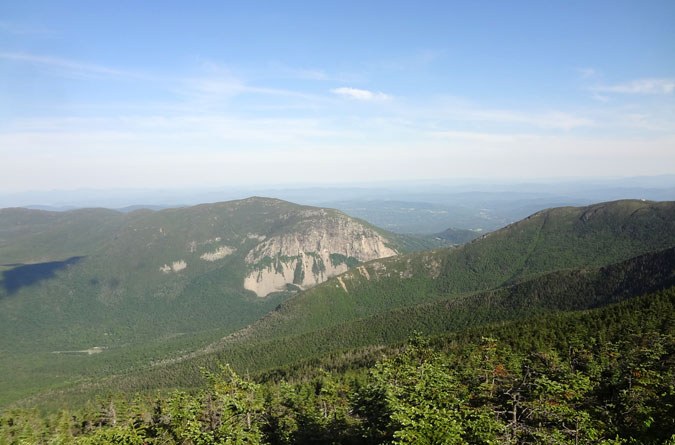
The Mt. Flume summit view is grand, peering for the first time across the vast expanse of the Pemigewasset Wilderness. It’s one thing to say you’re going to hike the 31.5 mile loop, but to then see the entire trek presented before you in the fashion of a real-life topographical map is quite humbling. Like a person afraid of heights climbing a ladder, it’s almost better to not look down. Or across. Just keep going, there’s no time to waste sightseeing.
6:59 AM, 7 miles
It’s short work from Mt. Flume to Mt. Liberty, the second peak of the day bagged.


I’ve always been a super fan of the Franconia Ridge Trail’s wooded stretch between Mt. Liberty and Little Haystack Mountain, and on this occasion I got the bright idea to run a good stretch of it. In the past I’ve opined that trail runners on Franconia Ridge must be rabid. Running at this stage in the hike clearly proves one thing: I’m not right in the head. In fairness to irrational thinking, my “strategy” was to get as far as I could as early as I could. Eventually I reached a speed bump, the short but rugged climb to the summit of Little Haystack Mountain.


8:00 AM, 9.5-ish miles
Atop the Mt. Lincoln summit, elevation 5,089 feet. Just passing through…well, okay, time for just one picture:

8:45 AM, 10.5 miles
The summit of Mt. Lafayette, the high point of the hike at 5,260 feet. To this point I hadn’t stopped for a proper break, so I set my alarm for ten minutes and sat down with a snack, something I was excited to do because it was a rare clear day with little wind on top. I barely made it through the ten minutes. Apparently when the wind is away on Mt. Lafayette, the black flies will play.

On the descent of Mt. Lafayette I caught up with a woman I’d previously passed somewhere between Mt. Lincoln and Mt. Lafayette. “I’m dry,” she said. I gladly offered her some Gatorade and we continued along the trail exchanging pleasantries. Ultimately the conversation got to “Why?” Thru or section hikers all have a story for what drew them to the trail, but this isn’t a question day hikers often exchange. Then again, this isn’t a typical day hike.
“Well…” I began, feeling a bit sheepish about what I was going to say. The woman was at least ten years older than me, and my rationale was that I wasn’t getting any younger, so it was now or never. Her reaction was predictable, exactly what I was trying to avoid, but at least taken in good spirit. She was doing the loop for the same reasons, for which she deserved a lot of credit.
10:38 AM, 14.2 miles
Hello, Mt. Garfield. It wasn’t lost upon me that the loop was almost half complete and I was nearing the fastest known times that a few ultra trail runners have bagged the entire loop. And I thought I was crazy…


Just 0.3 of a mile off the summit I stopped at the Garfield Ridge Campsite stream for water. This is one of the best sources of water along the hike and it’s right next to the trail. A good strategy for staying hydrated on hikes is to drink as much as one can at water sources, so I filled my Gatorade bottle and sucked it all down before filling it again. To save time, I didn’t bother adding water to the Camelbak, knowing I could do this at the Galehead Hut.
To this point I’d felt great all along the hike, but as I made my way along the Garfield Ridge Trail, I suddenly felt like a crash test dummy hurtled at a reinforced wall. My legs were holding up, it was the rest of my body that felt drained, the lack of sleep now taking it’s toll. It seemed as though I could feel the gravitational pull of the bags sagging beneath my eyes. Making matters worse I started encountering trail runners on the reverse loop, as well as one woman who passed me going clockwise. The most any of them was carrying was a hydration pack, but some didn’t even have that. They certainly weren’t survival-blanket prepared. I hesitate to say the joke was on me, because I was starting to think I might need the blanket.
12:20 PM, 17.1 miles
Staggering up to the Galehead Hut, I drop my pack on the deck and go inside to fill my bladder. Overly self conscious at this point, I try to play it cool, hoping to not collapse like a drunkard on the floor. No one seems to notice my zombie appearance. At least, the straggling overnight hikers readying their packs to leave and the day hikers in for a lunch break are all too preoccupied to notice the apocalypse may be upon them. Lunch on the deck is a granola bar, banana, and a Gu packet. I even manage a coherent conversation. Things are picking up.
The good news: the next 0.8 miles up South Twin Mountain is the last serious climb of the hike. The bad news: it’s a serious climb, gaining 1,122 feet in elevation over a steep procession of quad-busting boulders. I’ve cramped up on this climb before so I take my time to avoid a repeat performance. And then I take a little more time.
1:32 PM, 17.9 miles
Sweet, sweet, South Twin Mountain summit, elevation 4,902 feet.

2:02 PM, 19ish miles
My left quad starts to cramp. I thought I’d been hydrating enough, but the comfortable temperatures probably led me to be less vigilant than I would have been on a more humid day. The most ominous part of this problem, however, is that I’m on a flat stretch. Needless to say this became an “opportunity” for another timed ten-minute break, during which I chased down as much water as I could stomach with a Snickers bar.
The brief respite did the trick. Once back in motion there were no more cramping recurrences.
3:06 PM, 21.2 miles
Atop Mt. Bond, elevation 4,698. At this point I’m purely focusing on short-term goals, and now there’s only one 4K summit left.

Typically the ascent of Bondcliff is fairly easy, but by this point my legs were playing the role of stubborn mule. A few overnight hikers quickly identified what I was up to and offered words of encouragement, which truly helped. Experiences such as this are what makes hikers special, and the torture all worthwhile.

3:45 PM, 22.4 miles
Bondcliff.
The 4.4-mile descent of Bondcliff seems to be never ending, in part because I’ve already mentally completed the hike, which doesn’t bode well for the remaining 4.4-mile flat stretch along the Wilderness Trail and the Lincoln Woods Trail. Upon reaching the flat I get the not-so-bright idea to start running. Yeah, this doesn’t last long. I’m in no danger of breaking any speed records, and my personal best was previously two days, so I figure it’s worth leaving room for improvement next time.
Next time?
Stupid is as stupid does.
6:37 PM, 31.5 miles, 14 hours and 17 minutes
The end.
A great read! I’ve been looking into this hike for a bit now. I think I’ll do it in 2 or 3 days.
Thank you for sharing! I’m not ready to try it myself, but maybe someday!
I would say brave, adventurous and prepared rather than stupid! what an accomplishment!! read the summer/fall 2019 Appalachia book for an account of a 15 year old girl who does the pemi loop solo!
THANKS! I really enjoy reading your posts!!
i’m headed out for a 50 road walk (country roads) today…head up to the whites in September when the bugs have left for the season…
I just did this yesterday. I was waaay overpacked and it took me 18 hours. Epic day! Amazing views.