17.6 miles (round trip); Bondcliff elevation 4,265 feet
10-12 hours
Difficulty: Pack the Aleve
Let’s see if this makes sense: there’s no truly difficult part of climbing Bondcliff in New Hampshire’s White Mountains and the Pemigewasset Wilderness. The first 50 percent of the hike covering the Lincoln Woods Trail and Wilderness Trail is all flat, heavily traveled ground. Yes, there are a few steep sections on the Bondcliff Trail—show me a 4,000-foot mountain in the Northeast that doesn’t have some serious ups—but even these are quite forgiving by White Mountains’ standards.
So why the second most difficult trail rating on Northeast Hikes? What the Bondcliff Trail lacks in challenging terrain is more than accounted for in sheer distance. A 17.6-mile round-trip day hike is no joke in the summer, add winter’s coat and you better eat your Wheaties. Not to mention have a fixed turnaround time.

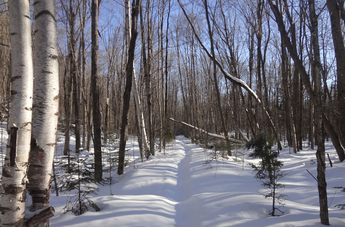
The hike begins at the Lincoln Woods Visitor’s Center by crossing a suspension bridge over the East Branch of the Pemigewasset River. The first 2.6 miles of the Lincoln Woods Trail is wide enough for a delivery truck and heavily packed from a steady stream of snowshoers, cross-country skiers and dog walkers, many of whom are destined for the Osseo, Black Pond or Franconia Falls trails.

Never mind the necessity of the Lincoln Woods Trail, many people come here for the pure beauty. Arrive early to beat the crowds and in winter you’ll be rewarded with views through the bare-limbed trees of Mt. Flume basking in the morning sun, along with a multitude of short side trails to the East Branch river that offer enjoyable rest spots. Glimpses of Mt Bond can even be seen in a few places along the river.
While it’s easy to appreciate Mother Nature at her finest during the beginning of the hike, it’s worth noting that on the way out, when your feet are screaming uncle and your legs are reduced to jello, this section can be monotonous, laborious, over crowded, and seemingly never ending. What a difference 15 miles can make!
After 2.6 miles on the Lincoln Woods Trail, at the junction with the Franconia Falls Trail, there’s a footbridge crossing Franconia Brook.


Upon crossing Franconia Brook, the Lincoln Woods Trail soon turns into the Wilderness trail, a name change signified by the entrance into the Pemigewasset Wilderness. The Wilderness Trail provides a 1.8 mile trek to the Bondcliff Trail, a stretch that is every bit as easy going as the Lincoln Woods Trail, but in winter receives a fraction of the traffic.
I had the pleasure of being reminded that the early bird gets to break trail. Normally I relish these opportunities, but facing a foot of fresh snow with 14.7 miles of hiking remaining, I got to thinking dinner plans with the family were out the window. My packed water supply was also in question.
The Bondcliff Trail veers off on the left, and for the early going is every bit as easy as the Wilderness Trail. Much of the Bondcliff Trail covers old logging roads with several Black Brook crossings. These are mostly frozen over in the winter, except for one open spot that I fortuitously reached on the return trip just as my Camelbak ran dry. Even when open this brook crossing was passable in snowshoes.
After a steep section the trail opens up and crosses what in the summer is a loose gravel bank. In the winter this is easy once the path has been broken, but can be formidable with thigh-deep snow when there’s no semblance of a trail. This open spot also offers a sneak-peek view of Bondcliff and the remaining climb. Depending on the fullness of your glass, this can either be rejuvenating or crushing.


After the gravel bank the trail dips into the final brook crossing and climbs for a short bit up the steep bank on the opposite side. Most of the remaining hike is a long, gradual, horizontal ascent of Bondcliff’s sharp upper slope.

On the way back down, near where the above photo was taken, I reached a spot packed by snowshoers with no one in sight. At first I thought it was a mirage and was happy for the illusion of an easier trail. A little further along I caught up with the group of five. When asked if I’d made it to the summit, I felt sheepish answering in the wake of their (likely) difficult decision to turn around when they were so close. Hats off to them for knowing when to fold ’em. In many regards that’s a bigger accomplishment than summiting.
Speaking of reaching the summit…remember when I said there were no difficult parts on the Bondcliff Trail? That may have been an itsy-bitsy, teeny-weeny, fib. Just before treeline there’s a ledge that can be tricky in winter. It’s the one spot where a mountaineering axe would come in handy. Naturally, I’d left mine in the car. Using my trekking poles, knees, and nearly every other body part for leverage, I was able to get over the hump.

The last jaunt to the Bondcliff summit is all open and exposed, so it’s a good idea to gear up first. The higher elevation winds were reported to be in the 65-miles-per-hour range on this day, which I believed after being knocked on my keister. The open ridge is mostly ice and hard-crusted snow; crampons would be useful here, but since I didn’t plan on continuing to Mt. Bond or dillydallying on top, I kept my snowshoes on to save time.

In winter with all the ice it’s especially important to exercise caution (not to mention common sense) around the cliffs. Steer well clear in inclement weather, ideally by not summiting in conditions where visibility is compromised. When the views are unobstructed, this climb is every bit worth the grueling 8.8-mile trek back.


Directions
Take exit 32 on I-93 and at the end of the ramp turn left onto Rt. 112 East, also the Kancamagus Highway. Approximately 5.6 miles from the exit is the Lincoln Woods Visitor Center parking lot, which has a daily parking fee.
Good information, planning a hike of the Whites and Washington later this year..
That was an incredible hike. Hope your life insurance is paid up.
Hi there, You have done an incredible job. I will definitely digg it and personally suggest to my friends. I am sure they’ll be benefited from this site.
I¡¦m not positive where you are getting your information, however good topic. I needs to spend some time learning much more or working out more. Thanks for excellent info I used to be searching for this information for my mission.
Great tremendous things here. I’m very glad to look your article. Thank you so much and i am taking a look ahead to contact you. Will you please drop me a mail?
you are actually a good webmaster. The website loading velocity is amazing. It seems that you are doing any distinctive trick. In addition, The contents are masterpiece. you’ve done a excellent process on this subject!
We are a group of volunteers and opening a new scheme in our community. Your website offered us with valuable info to work on. You’ve done a formidable job and our entire community will be thankful to you.
I truly wanted to post a brief comment to be able to thank you for some of the lovely pointers you are sharing at this site. My incredibly long internet search has at the end of the day been honored with excellent facts and techniques to share with my good friends. I ‘d express that most of us site visitors are really lucky to exist in a wonderful site with so many special people with insightful tips and hints. I feel rather blessed to have come across your site and look forward to so many more entertaining moments reading here. Thanks a lot once more for all the details.
We are a group of volunteers and opening a new scheme in our community. Your website offered us with valuable info to work on. You’ve done a formidable job and our entire community will be thankful to you.
Wow, marvelous weblog layout! How lengthy have you been blogging for? you made blogging glance easy. The overall look of your website is fantastic, as well as the content!
Your point of view caught my eye and was very interesting. Thanks. I have a question for you.
Hi there, You have done an incredible job. I will definitely digg it and personally suggest to my friends. I am sure they’ll be benefited from this site.
Your point of view caught my eye and was very interesting. Thanks. I have a question for you.
Your point of view caught my eye and was very interesting. Thanks. I have a question for you.
Thanks for sharing. I read many of your blog posts, cool, your blog is very good.
Can you be more specific about the content of your article? After reading it, I still have some doubts. Hope you can help me.
I don’t think the title of your article matches the content lol. Just kidding, mainly because I had some doubts after reading the article.
Your point of view caught my eye and was very interesting. Thanks. I have a question for you.
Your article helped me a lot, is there any more related content? Thanks!
Hi there, You’ve done an incredible job. I will definitely digg it and personally suggest to my friends. I’m confident they will be benefited from this website.
I have been exploring for a little bit for any high quality articles or blog posts in this sort of area . Exploring in Yahoo I at last stumbled upon this site. Reading this info So i?¦m satisfied to convey that I have a very excellent uncanny feeling I discovered exactly what I needed. I so much without a doubt will make sure to do not disregard this web site and give it a look regularly.
hello!,I like your writing very much! percentage we be in contact extra about your post on AOL? I require a specialist on this area to solve my problem. Maybe that’s you! Having a look forward to peer you.
Nice post. I was checking constantly this blog and I am impressed! Very useful info specifically the last part 🙂 I care for such info a lot. I was looking for this particular info for a long time. Thank you and good luck.
I was curious if you ever thought of changing the layout of your site? Its very well written; I love what youve got to say. But maybe you could a little more in the way of content so people could connect with it better. Youve got an awful lot of text for only having 1 or 2 pictures. Maybe you could space it out better?
I’m impressed, I have to say. Really hardly ever do I encounter a blog that’s each educative and entertaining, and let me tell you, you’ve gotten hit the nail on the head. Your thought is outstanding; the issue is something that not enough people are speaking intelligently about. I am very glad that I stumbled throughout this in my search for one thing regarding this.
he blog was how do i say it… relevant, finally something that helped me. Thanks
Its good as your other posts : D, thanks for posting.
I just like the helpful info you supply for your articles. I’ll bookmark your weblog and test once more right here regularly. I am relatively sure I’ll be told many new stuff right right here! Good luck for the next!
Really clean web site, thankyou for this post.
I¦ve been exploring for a bit for any high-quality articles or weblog posts in this sort of house . Exploring in Yahoo I ultimately stumbled upon this web site. Reading this info So i¦m satisfied to show that I’ve a very excellent uncanny feeling I discovered just what I needed. I most for sure will make sure to don¦t omit this web site and provides it a glance regularly.
hi!,I love your writing so a lot! share we communicate more about your post on AOL? I need a specialist in this house to solve my problem. Maybe that is you! Taking a look forward to peer you.
Great V I should certainly pronounce, impressed with your site. I had no trouble navigating through all tabs and related info ended up being truly easy to do to access. I recently found what I hoped for before you know it at all. Quite unusual. Is likely to appreciate it for those who add forums or anything, site theme . a tones way for your customer to communicate. Nice task..
Saved as a favorite, I really like your blog!
Yay google is my world beater aided me to find this great web site! .
excellent post, very informative. I wonder why the other experts of this sector do not notice this. You must continue your writing. I’m confident, you’ve a huge readers’ base already!
An impressive share, I just given this onto a colleague who was doing a little analysis on this. And he in fact bought me breakfast because I found it for him.. smile. So let me reword that: Thnx for the treat! But yeah Thnkx for spending the time to discuss this, I feel strongly about it and love reading more on this topic. If possible, as you become expertise, would you mind updating your blog with more details? It is highly helpful for me. Big thumb up for this blog post!
Thank you for another informative blog. Where else could I get that kind of information written in such an ideal way? I’ve a project that I am just now working on, and I have been on the look out for such information.
magnificent issues altogether, you just received a new reader. What would you recommend in regards to your publish that you just made a few days ago? Any certain?
I really appreciate this post. I have been looking all over for this! Thank goodness I found it on Bing. You have made my day! Thank you again!
Enjoyed studying this, very good stuff, appreciate it. “Nothing happens to any thing which that thing is not made by nature to bear.” by Marcus Aurelius Antoninus.
Write more, thats all I have to say. Literally, it seems as though you relied on the video to make your point. You obviously know what youre talking about, why waste your intelligence on just posting videos to your weblog when you could be giving us something enlightening to read?
Just a smiling visitor here to share the love (:, btw outstanding layout.
It’s a pity you don’t have a donate button! I’d certainly donate to this superb blog! I guess for now i’ll settle for bookmarking and adding your RSS feed to my Google account. I look forward to brand new updates and will share this site with my Facebook group. Talk soon!
Its excellent as your other posts : D, regards for putting up. “Reason is the substance of the universe. The design of the world is absolutely rational.” by Georg Wilhelm Friedrich Hegel.
Can I just say what a aid to search out somebody who actually knows what theyre talking about on the internet. You positively know how you can carry a problem to light and make it important. More individuals must read this and perceive this facet of the story. I cant consider youre no more popular since you positively have the gift.
I dugg some of you post as I thought they were very useful very beneficial
The Pink Salt Trick is a minimalist but effective morning routine: Just drink a glass of lukewarm water mixed with a pinch of Himalayan pink salt as soon as you wake up.
Hey, you used to write magnificent, but the last several posts have been kinda boring… I miss your super writings. Past few posts are just a little out of track! come on!
The Pink Salt Trick is a minimalist but effective morning routine: Just drink a glass of lukewarm water mixed with a pinch of Himalayan pink salt as soon as you wake up.
I am really impressed with your writing skills as well as with the layout on your weblog. Is this a paid theme or did you customize it yourself? Either way keep up the nice quality writing, it is rare to see a great blog like this one today..
Hey there this is somewhat of off topic but I was wanting to know if blogs use WYSIWYG editors or if you have to manually code with HTML. I’m starting a blog soon but have no coding skills so I wanted to get advice from someone with experience. Any help would be enormously appreciated!
Some genuinely nice and utilitarian information on this site, likewise I think the pattern holds good features.
I like this web site very much, Its a really nice billet to read and get information. “Misogynist A man who hates women as much as women hate one another.” by H.L. Mencken.
I like this site very much, Its a really nice place to read and receive information.
But wanna input on few general things, The website pattern is perfect, the content material is real superb. “Good judgment comes from experience, and experience comes from bad judgment.” by Barry LePatner.
Thanks a lot for sharing this with all of us you actually know what you are talking about! Bookmarked. Kindly also visit my website =). We could have a link exchange arrangement between us!
Have you ever thought about creating an ebook or guest authoring on other sites? I have a blog based on the same ideas you discuss and would really like to have you share some stories/information. I know my viewers would value your work. If you’re even remotely interested, feel free to send me an e-mail.
What i don’t understood is in fact how you are no longer actually much more neatly-appreciated than you may be now. You’re very intelligent. You realize therefore considerably in terms of this matter, produced me individually believe it from numerous numerous angles. Its like women and men don’t seem to be involved unless it is something to accomplish with Girl gaga! Your individual stuffs outstanding. At all times handle it up!
Good info. Lucky me I reach on your website by accident, I bookmarked it.
This web site is mostly a walk-via for all the information you needed about this and didn’t know who to ask. Glimpse right here, and also you’ll undoubtedly uncover it.
Thanks for the sensible critique. Me & my neighbor were just preparing to do some research on this. We got a grab a book from our area library but I think I learned more clear from this post. I’m very glad to see such wonderful info being shared freely out there.
I see something genuinely special in this site.
You made some clear points there. I did a search on the subject and found most persons will approve with your site.
Good ?V I should definitely pronounce, impressed with your web site. I had no trouble navigating through all tabs and related info ended up being truly easy to do to access. I recently found what I hoped for before you know it at all. Quite unusual. Is likely to appreciate it for those who add forums or anything, website theme . a tones way for your customer to communicate. Excellent task..
WONDERFUL Post.thanks for share..more wait .. …
It’s really a nice and useful piece of information. I’m glad that you shared this useful information with us. Please keep us up to date like this. Thanks for sharing.
Wohh precisely what I was looking for, appreciate it for posting.
Very well written information. It will be beneficial to anybody who usess it, including me. Keep doing what you are doing – looking forward to more posts.
Very interesting information!Perfect just what I was looking for!
An impressive share, I just given this onto a colleague who was doing a little analysis on this. And he in fact bought me breakfast because I found it for him.. smile. So let me reword that: Thnx for the treat! But yeah Thnkx for spending the time to discuss this, I feel strongly about it and love reading more on this topic. If possible, as you become expertise, would you mind updating your blog with more details? It is highly helpful for me. Big thumb up for this blog post!
I view something genuinely special in this web site.
Pretty section of content. I just stumbled upon your blog and in accession capital to assert that I get in fact enjoyed account your blog posts. Anyway I will be subscribing to your feeds and even I achievement you access consistently fast.
Excellent blog here! Also your website loads up fast! What web host are you using? Can I get your affiliate link to your host? I wish my site loaded up as quickly as yours lol
I love reading and I think this website got some genuinely useful stuff on it! .
Very interesting points you have mentioned, thanks for posting.
Thanx for the effort, keep up the good work Great work, I am going to start a small Blog Engine course work using your site I hope you enjoy blogging with the popular BlogEngine.net.Thethoughts you express are really awesome. Hope you will right some more posts.
you may have an amazing blog right here! would you wish to make some invite posts on my blog?
Very good written post. It will be beneficial to anyone who usess it, including myself. Keep doing what you are doing – looking forward to more posts.
I love your blog.. very nice colors & theme. Did you create this website yourself? Plz reply back as I’m looking to create my own blog and would like to know wheere u got this from. thanks
When I originally commented I clicked the -Notify me when new comments are added- checkbox and now each time a comment is added I get four emails with the same comment. Is there any way you can remove me from that service? Thanks!
This blog is definitely rather handy since I’m at the moment creating an internet floral website – although I am only starting out therefore it’s really fairly small, nothing like this site. Can link to a few of the posts here as they are quite. Thanks much. Zoey Olsen
Some genuinely fantastic posts on this site, appreciate it for contribution. “The key to everything is patience. You get the chicken by hatching the egg, not by smashing it.” by Arnold Glasgow.
I like this web site so much, saved to my bookmarks. “I don’t care what is written about me so long as it isn’t true.” by Dorothy Parker.
I just couldn’t depart your web site before suggesting that I extremely enjoyed the standard information a person provide for your visitors? Is going to be back often in order to check up on new posts
I have read a few excellent stuff here. Definitely worth bookmarking for revisiting. I wonder how a lot effort you put to create the sort of excellent informative web site.
Thanx for the effort, keep up the good work Great work, I am going to start a small Blog Engine course work using your site I hope you enjoy blogging with the popular BlogEngine.net.Thethoughts you express are really awesome. Hope you will right some more posts.
Hi there, just become alert to your blog thru Google, and located that it’s truly informative. I am going to watch out for brussels. I’ll be grateful when you continue this in future. A lot of other people will likely be benefited from your writing. Cheers!
Some truly interesting information, well written and loosely user pleasant.
Well I sincerely liked studying it. This information offered by you is very constructive for correct planning.
Great post. I used to be checking constantly this blog and I am inspired! Extremely useful info specially the last section 🙂 I deal with such information a lot. I was seeking this certain information for a very lengthy time. Thanks and best of luck.
I wanted to thank you for this great read!! I definitely enjoying every little bit of it I have you bookmarked to check out new stuff you post…
I loved as much as you’ll receive carried out right here. The sketch is tasteful, your authored subject matter stylish. nonetheless, you command get got an shakiness over that you wish be delivering the following. unwell unquestionably come more formerly again as exactly the same nearly a lot often inside case you shield this increase.
Everyone loves what you guys are usually up too. This sort of clever work and coverage! Keep up the wonderful works guys I’ve added you guys to my blogroll.
I and my pals have already been viewing the best thoughts found on your site then at once I got an awful feeling I never thanked the web blog owner for those secrets. These young boys became consequently excited to read them and now have seriously been making the most of those things. Thank you for simply being considerably kind as well as for settling on this form of excellent guides most people are really eager to be informed on. My honest regret for not expressing appreciation to you earlier.
I would like to thnkx for the efforts you have put in writing this blog. I am hoping the same high-grade blog post from you in the upcoming as well. In fact your creative writing abilities has inspired me to get my own blog now. Really the blogging is spreading its wings quickly. Your write up is a good example of it.
Thank you for the auspicious writeup. It if truth be told was a entertainment account it. Glance complicated to more added agreeable from you! By the way, how could we keep in touch?
I went over this website and I think you have a lot of fantastic information, bookmarked (:.
I simply could not depart your site before suggesting that I really loved the usual information a person supply for your guests? Is gonna be back incessantly in order to inspect new posts
I was just searching for this information for some time. After 6 hours of continuous Googleing, finally I got it in your web site. I wonder what’s the lack of Google strategy that don’t rank this kind of informative web sites in top of the list. Normally the top websites are full of garbage.
I haven’t checked in here for a while since I thought it was getting boring, but the last several posts are good quality so I guess I will add you back to my everyday bloglist. You deserve it my friend 🙂
Great V I should certainly pronounce, impressed with your web site. I had no trouble navigating through all the tabs and related information ended up being truly easy to do to access. I recently found what I hoped for before you know it in the least. Reasonably unusual. Is likely to appreciate it for those who add forums or something, website theme . a tones way for your client to communicate. Nice task..
I really appreciate this post. I have been looking everywhere for this! Thank goodness I found it on Bing. You have made my day! Thx again
You could definitely see your expertise in the work you write. The sector hopes for even more passionate writers such as you who are not afraid to mention how they believe. All the time go after your heart. “History is the version of past events that people have decided to agree upon.” by Napoleon.
This is the appropriate blog for anybody who wants to search out out about this topic. You notice a lot its almost laborious to argue with you (not that I actually would want…HaHa). You definitely put a brand new spin on a topic thats been written about for years. Great stuff, simply nice!
I like this blog its a master peace ! Glad I detected this on google .
I cherished as much as you’ll obtain performed proper here. The sketch is attractive, your authored material stylish. however, you command get bought an impatience over that you wish be handing over the following. ill certainly come further before again as precisely the same just about a lot steadily within case you defend this hike.
Wohh just what I was searching for, thanks for posting.
Thank you a lot for giving everyone a very marvellous opportunity to read in detail from here. It is usually very cool plus packed with fun for me and my office colleagues to search the blog nearly three times in one week to learn the newest guidance you have got. And indeed, I’m certainly amazed with your attractive secrets you serve. Some 3 points on this page are definitely the best we’ve ever had.
I love your blog.. very nice colors & theme. Did you design this website yourself or did you hire someone to do it for you? Plz reply as I’m looking to create my own blog and would like to find out where u got this from. thanks a lot
I was wondering if you ever considered changing the layout of your website? Its very well written; I love what youve got to say. But maybe you could a little more in the way of content so people could connect with it better. Youve got an awful lot of text for only having 1 or 2 images. Maybe you could space it out better?
I genuinely enjoy reading through on this website, it contains wonderful blog posts. “Don’t put too fine a point to your wit for fear it should get blunted.” by Miguel de Cervantes.
I like this weblog very much, Its a real nice post to read and receive information. “There is no exercise better for the heart than reaching down and lifting people up.” by John Andrew Holmes.
I am now not certain where you are getting your info, however great topic. I needs to spend a while finding out more or understanding more. Thank you for fantastic info I used to be looking for this info for my mission.
Admiring the time and energy you put into your site and in depth information you offer. It’s great to come across a blog every once in a while that isn’t the same unwanted rehashed information. Excellent read! I’ve bookmarked your site and I’m including your RSS feeds to my Google account.
Some really fantastic content on this website , regards for contribution.
I have been absent for some time, but now I remember why I used to love this website. Thank you, I will try and check back more often. How frequently you update your website?
Have you heard about ThyraFemme Balance? This natural supplement is becoming a sensation among women worldwide because it provides a real, safe, and natural solution for those struggling with hormonal imbalance, slow metabolism, weight gain, fatigue, and lack of energy.
Flash Burn is a revolutionary natural supplement that has been transforming the lives of thousands of people struggling with excess weight. Developed with a 100 natural and scientifically proven formula
Very good written information. It will be useful to anyone who usess it, including myself. Keep doing what you are doing – looking forward to more posts.
An impressive share, I just given this onto a colleague who was doing a little analysis on this. And he in fact bought me breakfast because I found it for him.. smile. So let me reword that: Thnx for the treat! But yeah Thnkx for spending the time to discuss this, I feel strongly about it and love reading more on this topic. If possible, as you become expertise, would you mind updating your blog with more details? It is highly helpful for me. Big thumb up for this blog post!
The Pink Salt Trick is a minimalist but effective morning routine: Just drink a glass of lukewarm water mixed with a pinch of Himalayan pink salt as soon as you wake up.
certainly like your web-site but you have to take a look at the spelling on quite a few of your posts. A number of them are rife with spelling issues and I to find it very troublesome to inform the reality on the other hand I will certainly come again again.
I do like the manner in which you have presented this problem and it really does supply me personally a lot of fodder for consideration. Nonetheless, through what precisely I have experienced, I just hope as the opinions pack on that people stay on point and don’t embark upon a tirade associated with some other news du jour. All the same, thank you for this outstanding point and while I do not necessarily go along with this in totality, I value your point of view.
WONDERFUL Post.thanks for share..extra wait .. …
Right now it sounds like BlogEngine is the best blogging platform out there right now. (from what I’ve read) Is that what you are using on your blog?
I really like your writing style, superb info , regards for putting up : D.
I was studying some of your articles on this website and I believe this internet site is really instructive! Keep on putting up.
I have recently started a web site, the info you provide on this web site has helped me tremendously. Thank you for all of your time & work.
Great write-up, I am regular visitor of one¦s website, maintain up the nice operate, and It is going to be a regular visitor for a lengthy time.
Pretty element of content. I just stumbled upon your website and in accession capital to claim that I acquire in fact enjoyed account your weblog posts. Any way I’ll be subscribing in your augment and even I achievement you get entry to constantly quickly.
I love it when people come together and share opinions, great blog, keep it up.
Appreciate it for this post, I am a big big fan of this internet site would like to keep updated.
A person essentially help to make seriously posts I would state. This is the very first time I frequented your web page and thus far? I amazed with the research you made to make this particular publish amazing. Magnificent job!
What i don’t realize is in reality how you are now not really a lot more well-appreciated than you may be now. You’re very intelligent. You recognize thus significantly in the case of this topic, produced me for my part consider it from numerous various angles. Its like men and women don’t seem to be interested except it is something to do with Lady gaga! Your own stuffs great. All the time handle it up!
I have been examinating out a few of your stories and i can claim pretty nice stuff. I will make sure to bookmark your site.
I have recently started a site, the information you offer on this web site has helped me tremendously. Thank you for all of your time & work.
Have you ever thought about creating an ebook or guest authoring on other websites? I have a blog based upon on the same topics you discuss and would love to have you share some stories/information. I know my visitors would appreciate your work. If you’re even remotely interested, feel free to shoot me an e mail.
Hello.This post was really fascinating, especially because I was searching for thoughts on this issue last Thursday.
you have a great blog here! would you like to make some invite posts on my blog?
You have brought up a very excellent details, appreciate it for the post.
I’d need to test with you here. Which is not one thing I normally do! I enjoy reading a publish that can make people think. Additionally, thanks for allowing me to comment!
You have brought up a very excellent points, thanks for the post.
Hi , I do believe this is an excellent blog. I stumbled upon it on Yahoo , i will come back once again. Money and freedom is the best way to change, may you be rich and help other people.
I have been reading out a few of your posts and it’s pretty nice stuff. I will surely bookmark your site.
There are some fascinating deadlines on this article but I don’t know if I see all of them center to heart. There is some validity but I’ll take maintain opinion till I look into it further. Good article , thanks and we want more! Added to FeedBurner as effectively
I think this is among the most significant information for me. And i’m glad reading your article. But wanna remark on few general things, The website style is ideal, the articles is really great : D. Good job, cheers
great points altogether, you just gained a brand new reader. What would you suggest in regards to your post that you made some days ago? Any positive?
I love your writing style truly loving this internet site.
I like what you guys are up also. Such clever work and reporting! Keep up the excellent works guys I have incorporated you guys to my blogroll. I think it’ll improve the value of my web site :).
After examine a number of of the blog posts on your website now, and I truly like your means of blogging. I bookmarked it to my bookmark web site listing and might be checking again soon. Pls take a look at my web page as properly and let me know what you think.
You can certainly see your skills in the work you write. The world hopes for even more passionate writers like you who aren’t afraid to say how they believe. Always follow your heart.
I think you have mentioned some very interesting details, thanks for the post.
Magnificent goods from you, man. I’ve bear in mind your stuff prior to and you’re simply too fantastic. I actually like what you have got here, certainly like what you are stating and the best way wherein you are saying it. You’re making it enjoyable and you continue to take care of to stay it sensible. I cant wait to learn far more from you. This is really a terrific website.
After examine just a few of the weblog posts on your web site now, and I really like your means of blogging. I bookmarked it to my bookmark website list and shall be checking back soon. Pls check out my web site as effectively and let me know what you think.
Sweet site, super style and design, very clean and use friendly.
Hey very nice site!! Man .. Beautiful .. Amazing .. I’ll bookmark your website and take the feeds also…I am happy to find a lot of useful information here in the post, we need work out more strategies in this regard, thanks for sharing. . . . . .
Undeniably believe that that you stated. Your favourite reason seemed to be on the web the simplest factor to bear in mind of. I say to you, I certainly get annoyed at the same time as folks consider concerns that they just do not realize about. You controlled to hit the nail upon the top and also defined out the entire thing without having side effect , folks could take a signal. Will likely be back to get more. Thanks
Really clean site, thanks for this post.
I visited a lot of website but I conceive this one contains something special in it in it
I believe you have remarked some very interesting details, regards for the post.
I’ve recently started a blog, the information you provide on this site has helped me tremendously. Thank you for all of your time & work.
Hiya, I am really glad I have found this info. Nowadays bloggers publish only about gossips and net and this is actually frustrating. A good blog with exciting content, this is what I need. Thank you for keeping this web-site, I will be visiting it. Do you do newsletters? Can not find it.
Wow! Thank you! I always needed to write on my blog something like that. Can I take a fragment of your post to my website?
I am often to blogging and i really appreciate your content. The article has really peaks my interest. I am going to bookmark your site and keep checking for new information.
Merely a smiling visitant here to share the love (:, btw great pattern. “Everything should be made as simple as possible, but not one bit simpler.” by Albert Einstein.
Great tremendous things here. I?¦m very satisfied to look your article. Thank you so much and i am having a look forward to touch you. Will you please drop me a e-mail?
I’ve recently started a site, the information you offer on this web site has helped me tremendously. Thanks for all of your time & work.
Hey! This post could not be written any better! Reading through this post reminds me of my good old room mate! He always kept chatting about this. I will forward this page to him. Fairly certain he will have a good read. Thanks for sharing!
I have read some excellent stuff here. Certainly value bookmarking for revisiting. I surprise how so much attempt you place to make this type of excellent informative website.
You should take part in a contest for one of the best blogs on the web. I will recommend this site!
you have a great blog here! would you like to make some invite posts on my blog?
Needed to draft you this very little remark to help thank you so much over again relating to the pleasing information you’ve discussed at this time. It’s quite surprisingly open-handed with people like you to grant openly all numerous people could have advertised for an e book to make some money for themselves, specifically now that you could have done it if you wanted. Those good ideas as well acted like a great way to be certain that other people online have similar desire like mine to understand way more with reference to this problem. I know there are a lot more pleasurable periods ahead for many who scan your site.
Good post and right to the point. I don’t know if this is actually the best place to ask but do you guys have any thoughts on where to hire some professional writers? Thx 🙂
I will immediately seize your rss feed as I can not to find your e-mail subscription link or newsletter service. Do you have any? Kindly let me know so that I could subscribe. Thanks.
Good ?V I should definitely pronounce, impressed with your site. I had no trouble navigating through all the tabs as well as related information ended up being truly simple to do to access. I recently found what I hoped for before you know it at all. Quite unusual. Is likely to appreciate it for those who add forums or anything, site theme . a tones way for your customer to communicate. Nice task..
I cling on to listening to the news broadcast speak about receiving free online grant applications so I have been looking around for the most excellent site to get one. Could you tell me please, where could i find some?
Great awesome things here. I?¦m very happy to see your post. Thank you so much and i am having a look forward to contact you. Will you kindly drop me a mail?
Pretty great post. I simply stumbled upon your weblog and wished to mention that I’ve really loved browsing your weblog posts. In any case I’ll be subscribing to your feed and I’m hoping you write again soon!
Great ?V I should definitely pronounce, impressed with your web site. I had no trouble navigating through all tabs as well as related information ended up being truly simple to do to access. I recently found what I hoped for before you know it at all. Reasonably unusual. Is likely to appreciate it for those who add forums or anything, site theme . a tones way for your customer to communicate. Excellent task..
Aw, this was a really nice post. In thought I want to put in writing like this additionally – taking time and precise effort to make a very good article… however what can I say… I procrastinate alot and on no account appear to get something done.
Very fantastic visual appeal on this website , I’d rate it 10 10.
Excellent post. I was checking constantly this blog and I am impressed! Extremely helpful info particularly the last part 🙂 I care for such info much. I was looking for this certain info for a long time. Thank you and best of luck.
I will immediately grab your rss feed as I can not find your email subscription link or e-newsletter service. Do you have any? Kindly let me know so that I could subscribe. Thanks.
I am really loving the theme/design of your site. Do you ever run into any web browser compatibility issues? A small number of my blog readers have complained about my site not operating correctly in Explorer but looks great in Chrome. Do you have any ideas to help fix this problem?
That is the right blog for anyone who wants to seek out out about this topic. You realize so much its almost laborious to argue with you (not that I really would want…HaHa). You definitely put a brand new spin on a subject thats been written about for years. Nice stuff, just great!
I know this if off topic but I’m looking into starting my own weblog and was wondering what all is required to get setup? I’m assuming having a blog like yours would cost a pretty penny? I’m not very web savvy so I’m not 100 certain. Any recommendations or advice would be greatly appreciated. Cheers
I’m really inspired with your writing talents and also with the structure in your blog. Is this a paid subject matter or did you modify it your self? Either way stay up the excellent quality writing, it is uncommon to look a great weblog like this one these days..
I got what you intend, thanks for posting.Woh I am thankful to find this website through google. “Food is the most primitive form of comfort.” by Sheila Graham.
An impressive share, I just given this onto a colleague who was doing a little analysis on this. And he in fact bought me breakfast because I found it for him.. smile. So let me reword that: Thnx for the treat! But yeah Thnkx for spending the time to discuss this, I feel strongly about it and love reading more on this topic. If possible, as you become expertise, would you mind updating your blog with more details? It is highly helpful for me. Big thumb up for this blog post!
I’d have to examine with you here. Which is not one thing I usually do! I take pleasure in reading a post that may make folks think. Additionally, thanks for permitting me to comment!
Excellent web site. Lots of helpful info here. I am sending it to a few friends ans additionally sharing in delicious. And naturally, thank you on your effort!
Hello! Do you know if they make any plugins to assist with SEO? I’m trying to get my blog to rank for some targeted keywords but I’m not seeing very good results. If you know of any please share. Cheers!
Hi my family member! I wish to say that this post is amazing, great written and include approximately all significant infos. I’d like to see more posts like this.
What i don’t understood is actually how you are not really much more well-liked than you might be right now. You are very intelligent. You realize thus considerably relating to this subject, produced me personally consider it from numerous varied angles. Its like women and men aren’t fascinated unless it’s one thing to do with Lady gaga! Your own stuffs great. Always maintain it up!
Its like you read my mind! You appear to know a lot about this, like you wrote the book in it or something. I think that you can do with a few pics to drive the message home a bit, but other than that, this is great blog. A fantastic read. I will definitely be back.
Wonderful site. Lots of useful info here. I am sending it to a few pals ans also sharing in delicious. And naturally, thanks to your effort!
I like the efforts you have put in this, thanks for all the great posts.
A person essentially lend a hand to make seriously articles I would state. That is the first time I frequented your website page and to this point? I surprised with the research you made to create this actual publish extraordinary. Magnificent job!
It’s really a cool and useful piece of information. I am glad that you shared this helpful information with us. Please keep us informed like this. Thanks for sharing.
I have been absent for a while, but now I remember why I used to love this website. Thanks, I will try and check back more frequently. How frequently you update your web site?
Some really interesting information, well written and broadly user pleasant.
Great remarkable things here. I am very satisfied to look your post. Thank you a lot and i’m taking a look forward to contact you. Will you kindly drop me a e-mail?
I know this if off topic but I’m looking into starting my own blog and was curious what all is required to get set up? I’m assuming having a blog like yours would cost a pretty penny? I’m not very web smart so I’m not 100 sure. Any recommendations or advice would be greatly appreciated. Appreciate it
I’m extremely impressed with your writing skills as smartly as with the format to your weblog. Is that this a paid topic or did you customize it yourself? Either way stay up the excellent high quality writing, it is uncommon to look a nice weblog like this one these days..
Whoa! This blog looks exactly like my old one! It’s on a entirely different topic but it has pretty much the same page layout and design. Great choice of colors!
I am not positive the place you are getting your info, however good topic. I must spend a while learning more or working out more. Thank you for wonderful info I used to be in search of this information for my mission.
fantastic post, very informative. I wonder why the other specialists of this sector don’t notice this. You should continue your writing. I’m sure, you have a great readers’ base already!
It’s hard to find knowledgeable people on this topic, but you sound like you know what you’re talking about! Thanks
Some genuinely nice stuff on this web site, I like it.
There is apparently a bundle to realize about this. I believe you made certain nice points in features also.
I believe you have mentioned some very interesting points, thanks for the post.
I genuinely enjoy reading on this site, it holds superb posts. “A short saying oft contains much wisdom.” by Sophocles.
This is really interesting, You’re a very skilled blogger. I have joined your feed and look forward to seeking more of your fantastic post. Also, I’ve shared your site in my social networks!
I’ve learn a few excellent stuff here. Certainly worth bookmarking for revisiting. I surprise how so much effort you set to make such a fantastic informative website.
I have learn some excellent stuff here. Definitely price bookmarking for revisiting. I surprise how so much attempt you set to make this kind of fantastic informative web site.
Hey very nice blog!! Guy .. Beautiful .. Amazing .. I will bookmark your site and take the feeds also…I am happy to search out a lot of useful info right here within the put up, we want work out extra techniques in this regard, thank you for sharing.
Outstanding post, you have pointed out some great points, I also think this s a very superb website.
You must take part in a contest for probably the greatest blogs on the web. I will advocate this site!
It’s really a great and helpful piece of information. I am happy that you just shared this useful information with us. Please keep us informed like this. Thank you for sharing.
I’ve been surfing online greater than 3 hours nowadays, but I never discovered any interesting article like yours. It’s beautiful price enough for me. Personally, if all web owners and bloggers made good content as you probably did, the net will likely be a lot more helpful than ever before.
hey there and thank you for your information – I have certainly picked up something new from right here. I did however expertise some technical points using this website, since I experienced to reload the web site lots of times previous to I could get it to load correctly. I had been wondering if your hosting is OK? Not that I am complaining, but slow loading instances times will very frequently affect your placement in google and could damage your quality score if advertising and marketing with Adwords. Anyway I’m adding this RSS to my email and can look out for a lot more of your respective exciting content. Ensure that you update this again very soon..
Hiya, I’m really glad I have found this info. Today bloggers publish only about gossips and web and this is actually annoying. A good site with exciting content, that’s what I need. Thank you for keeping this web-site, I’ll be visiting it. Do you do newsletters? Cant find it.
Hi there just wanted to give you a quick heads up. The text in your content seem to be running off the screen in Safari. I’m not sure if this is a format issue or something to do with internet browser compatibility but I figured I’d post to let you know. The layout look great though! Hope you get the problem resolved soon. Many thanks
Hello. excellent job. I did not anticipate this. This is a fantastic story. Thanks!
Way cool, some valid points! I appreciate you making this article available, the rest of the site is also high quality. Have a fun.
I got what you intend, thanks for putting up.Woh I am delighted to find this website through google. “Don’t be afraid of opposition. Remember, a kite rises against not with the wind.” by Hamilton Mabie.
Merely wanna admit that this is invaluable, Thanks for taking your time to write this.
fantastic put up, very informative. I’m wondering why the other specialists of this sector do not notice this. You must proceed your writing. I’m confident, you’ve a great readers’ base already!
I like this internet site because so much useful material on here : D.
What i don’t realize is if truth be told how you are now not really a lot more smartly-liked than you might be now. You are so intelligent. You already know therefore significantly relating to this subject, made me in my view believe it from a lot of various angles. Its like women and men are not fascinated until it’s something to do with Girl gaga! Your own stuffs outstanding. Always maintain it up!
certainly like your website however you need to test the spelling on quite a few of your posts. Several of them are rife with spelling issues and I find it very troublesome to inform the truth on the other hand I will definitely come again again.
Keep up the good work, I read few blog posts on this internet site and I believe that your web blog is very interesting and holds lots of great info .
you have a great blog here! would you like to make some invite posts on my blog?
Hi, I think your site might be having browser compatibility issues. When I look at your website in Safari, it looks fine but when opening in Internet Explorer, it has some overlapping. I just wanted to give you a quick heads up! Other then that, fantastic blog!
This is a topic close to my heart cheers, where are your contact details though?
We’re a gaggle of volunteers and starting a brand new scheme in our community. Your website provided us with helpful info to paintings on. You have performed a formidable activity and our entire neighborhood will be thankful to you.
Rattling clear website , thankyou for this post.
hello!,I like your writing very much! share we communicate more about your article on AOL? I need an expert on this area to solve my problem. Maybe that’s you! Looking forward to see you.
Thank you for sharing with us, I think this website really stands out : D.
You have brought up a very good details , thanks for the post.
Its wonderful as your other content : D, thankyou for putting up.
I truly appreciate this post. I¦ve been looking all over for this! Thank goodness I found it on Bing. You have made my day! Thx again
I am curious to find out what blog platform you’re working with? I’m experiencing some small security problems with my latest site and I’d like to find something more secure. Do you have any suggestions?
I conceive this internet site has got very fantastic written content content.
You made some clear points there. I looked on the internet for the subject and found most people will go along with with your website.
Enjoyed reading this, very good stuff, appreciate it.
I conceive you have noted some very interesting details , appreciate it for the post.
Hi there! I simply wish to give a huge thumbs up for the good info you have right here on this post. I can be coming again to your weblog for extra soon.
Nice read, I just passed this onto a friend who was doing a little research on that. And he just bought me lunch because I found it for him smile Therefore let me rephrase that: Thanks for lunch! “By nature, men are nearly alike by practice, they get to be wide apart.” by Confucius.
There is noticeably a bundle to realize about this. I believe you made certain nice points in features also.
Would love to forever get updated great site! .
I was reading through some of your articles on this website and I think this internet site is real instructive! Keep on putting up.
I love it when people come together and share opinions, great blog, keep it up.
I savor, result in I found exactly what I was having a look for. You’ve ended my four day long hunt! God Bless you man. Have a great day. Bye
Hey There. I found your blog using msn. This is an extremely well written article. I will make sure to bookmark it and come back to read more of your useful info. Thanks for the post. I’ll certainly comeback.
I got what you intend, thankyou for posting.Woh I am delighted to find this website through google. “Success is dependent on effort.” by Sophocles.
obviously like your web site however you need to check the spelling on quite a few of your posts. Many of them are rife with spelling problems and I find it very bothersome to tell the reality however I will definitely come again again.
I like reading and I conceive this website got some really utilitarian stuff on it! .
Yeah bookmaking this wasn’t a bad determination great post! .
Incredible! This blog looks exactly like my old one! It’s on a totally different topic but it has pretty much the same page layout and design. Excellent choice of colors!
I have been reading out a few of your stories and it’s pretty good stuff. I will surely bookmark your site.
I am lucky that I noticed this site, exactly the right info that I was searching for! .
What i do not understood is if truth be told how you are not actually much more smartly-liked than you may be right now. You are very intelligent. You know therefore significantly in the case of this topic, produced me in my view consider it from a lot of varied angles. Its like men and women are not fascinated until it is one thing to accomplish with Girl gaga! Your own stuffs great. Always care for it up!
I¦ve recently started a site, the info you offer on this site has helped me tremendously. Thanks for all of your time & work.
Wonderful web site. Plenty of helpful information here. I am sending it to some buddies ans also sharing in delicious. And obviously, thanks for your sweat!
Excellent read, I just passed this onto a colleague who was doing a little research on that. And he actually bought me lunch since I found it for him smile Therefore let me rephrase that: Thank you for lunch!
I really like your writing style, excellent information, thanks for posting : D.
Hello my friend! I want to say that this post is awesome, nice written and include almost all vital infos. I’d like to see more posts like this.
I like this web site so much, saved to favorites.
I was studying some of your articles on this site and I conceive this web site is rattling instructive! Continue posting.
I am often to blogging and i really appreciate your content. The article has really peaks my interest. I am going to bookmark your site and keep checking for new information.
I’ve been absent for a while, but now I remember why I used to love this site. Thank you, I will try and check back more often. How frequently you update your website?
I think this is one of the most significant info for me. And i am glad reading your article. But want to remark on some general things, The web site style is wonderful, the articles is really nice : D. Good job, cheers
Awsome blog! I am loving it!! Will be back later to read some more. I am taking your feeds also.
I conceive this web site holds some very great information for everyone : D.
I haven’t checked in here for some time since I thought it was getting boring, but the last few posts are good quality so I guess I will add you back to my everyday bloglist. You deserve it my friend 🙂
Appreciate it for all your efforts that you have put in this. very interesting info .
Great post, I conceive blog owners should larn a lot from this site its rattling user genial.
Very interesting information!Perfect just what I was searching for!
Hello! I just would like to give a huge thumbs up for the great info you have here on this post. I will be coming back to your blog for more soon.
magnificent post, very informative. I wonder why the other specialists of this sector do not notice this. You must continue your writing. I am confident, you have a great readers’ base already!
Hello! I’ve been reading your blog for a long time now and finally got the bravery to go ahead and give you a shout out from Humble Tx! Just wanted to say keep up the fantastic job!
Wonderful beat ! I would like to apprentice while you amend your site, how could i subscribe for a blog web site? The account aided me a acceptable deal. I had been a little bit acquainted of this your broadcast provided bright clear concept
I have been surfing on-line more than 3 hours today, but I never found any interesting article like yours. It’s beautiful price enough for me. In my view, if all site owners and bloggers made excellent content material as you did, the web might be much more useful than ever before. “Dreams have as much influence as actions.” by Stephane Mallarme.
I will immediately clutch your rss as I can not to find your email subscription hyperlink or newsletter service. Do you’ve any? Kindly let me recognise so that I may just subscribe. Thanks.
That is very interesting, You’re an overly professional blogger. I have joined your feed and look ahead to in the hunt for extra of your excellent post. Additionally, I’ve shared your site in my social networks!
Youre so cool! I dont suppose Ive learn anything like this before. So nice to search out somebody with some unique thoughts on this subject. realy thanks for starting this up. this web site is something that’s wanted on the net, someone with somewhat originality. helpful job for bringing one thing new to the internet!
I’m not sure why but this weblog is loading extremely slow for me. Is anyone else having this problem or is it a issue on my end? I’ll check back later and see if the problem still exists.
Some really great information, Sword lily I observed this.
I¦ve recently started a web site, the info you offer on this site has helped me tremendously. Thank you for all of your time & work.
Woah! I’m really enjoying the template/theme of this website. It’s simple, yet effective. A lot of times it’s difficult to get that “perfect balance” between usability and appearance. I must say that you’ve done a amazing job with this. Additionally, the blog loads very fast for me on Internet explorer. Superb Blog!
Howdy! This is my first visit to your blog! We are a group of volunteers and starting a new project in a community in the same niche. Your blog provided us valuable information to work on. You have done a marvellous job!
Great write-up, I’m normal visitor of one’s web site, maintain up the excellent operate, and It’s going to be a regular visitor for a lengthy time.
I enjoy you because of each of your hard work on this website. Debby enjoys working on investigation and it’s really easy to understand why. I notice all about the powerful form you convey insightful tips on your blog and as well strongly encourage contribution from the others on the area and our own daughter is actually discovering so much. Enjoy the remaining portion of the year. You are doing a superb job.
You made some respectable factors there. I regarded on the web for the difficulty and located most people will go along with together with your website.
Hello my family member! I wish to say that this post is amazing, great written and include almost all significant infos. I would like to look extra posts like this .
After all, what a great site and informative posts, I will upload inbound link – bookmark this web site? Regards, Reader.
Heya just wanted to give you a brief heads up and let you know a few of the pictures aren’t loading correctly. I’m not sure why but I think its a linking issue. I’ve tried it in two different internet browsers and both show the same outcome.
Would you be concerned with exchanging hyperlinks?
But wanna comment that you have a very decent internet site, I like the design it actually stands out.
I saw a lot of website but I think this one has got something extra in it in it
Very interesting details you have mentioned, thankyou for posting.
Regards for all your efforts that you have put in this. very interesting information.
Hello. fantastic job. I did not anticipate this. This is a great story. Thanks!
Hello! I could have sworn I’ve been to this blog before but after browsing through some of the post I realized it’s new to me. Anyways, I’m definitely happy I found it and I’ll be book-marking and checking back frequently!
I went over this site and I conceive you have a lot of great info , bookmarked (:.
I’ll immediately take hold of your rss as I can’t to find your email subscription hyperlink or e-newsletter service. Do you’ve any? Kindly allow me realize in order that I may just subscribe. Thanks.
Thank you for sharing with us, I believe this website really stands out : D.
Awesome blog! Is your theme custom made or did you download it from somewhere? A theme like yours with a few simple adjustements would really make my blog shine. Please let me know where you got your theme. With thanks
Thanks for the sensible critique. Me & my neighbor were just preparing to do a little research about this. We got a grab a book from our local library but I think I learned more from this post. I’m very glad to see such excellent information being shared freely out there.
Yeah bookmaking this wasn’t a speculative decision great post! .
Nice read, I just passed this onto a friend who was doing a little research on that. And he actually bought me lunch since I found it for him smile Therefore let me rephrase that: Thank you for lunch!
A person essentially help to make seriously posts I would state. This is the very first time I frequented your website page and thus far? I surprised with the research you made to make this particular publish incredible. Fantastic job!
I don’t even know how I ended up here, but I thought this post was great. I don’t know who you are but definitely you are going to a famous blogger if you aren’t already 😉 Cheers!
Your style is so unique compared to many other people. Thank you for publishing when you have the opportunity,Guess I will just make this bookmarked.2
Thank you for sharing with us, I think this website truly stands out : D.
Hello there! Do you know if they make any plugins to help with SEO? I’m trying to get my blog to rank for some targeted keywords but I’m not seeing very good gains. If you know of any please share. Kudos!
Loving the information on this web site, you have done outstanding job on the posts.
Hello, i think that i saw you visited my site so i came to “return the favor”.I’m attempting to find things to improve my site!I suppose its ok to use a few of your ideas!!
I conceive this web site holds some rattling great information for everyone. “The expert at anything was once a beginner.” by Hayes.
Very interesting topic, regards for putting up. “Experience a comb life gives you after you lose your hair.” by Judith Stern.
Very clean site, appreciate it for this post.
Hello there, I found your blog via Google while searching for a related topic, your site came up, it looks good. I have bookmarked it in my google bookmarks.
I have learn a few excellent stuff here. Definitely price bookmarking for revisiting. I surprise how so much attempt you put to create this kind of fantastic informative site.
What i do not understood is in fact how you’re not actually much more neatly-favored than you might be now. You are so intelligent. You understand thus significantly in the case of this subject, made me for my part believe it from so many varied angles. Its like men and women are not interested except it is one thing to do with Woman gaga! Your personal stuffs excellent. Always care for it up!
I was recommended this web site by my cousin. I am now not certain whether this post is written through him as nobody else understand such particular approximately my difficulty. You’re amazing! Thank you!
Wonderful beat ! I wish to apprentice even as you amend your site, how could i subscribe for a weblog site? The account aided me a appropriate deal. I have been a little bit acquainted of this your broadcast provided vibrant transparent concept
I really enjoy reading through on this web site, it contains great blog posts. “Dream no small dreams. They have no power to stir the souls of men.” by Victor Hugo.
I believe you have remarked some very interesting details, regards for the post.
I enjoy your work, thanks for all the informative content.
Howdy very cool web site!! Guy .. Excellent .. Amazing .. I will bookmark your web site and take the feeds also?KI am happy to find so many useful information here within the submit, we want develop more techniques in this regard, thanks for sharing. . . . . .
The primary strength of the Manav Sampada UP system is the complete digitization of employee service records, including promotions and transfers, which ensures transparency and easy access to an employee’s professional history. This paperless process significantly reduces reliance on manual file management across all state departments.
I went over this web site and I conceive you have a lot of superb info , saved to bookmarks (:.
Thank you for sharing with us, I conceive this website genuinely stands out : D.
This is a very good tips especially to those new to blogosphere, brief and accurate information… Thanks for sharing this one. A must read article.
Very interesting points you have noted, regards for putting up. “You can tell the ideas of a nation by it’s advertisements.” by Douglas South Wind.
I believe this site has some real wonderful information for everyone. “Philosophy triumphs easily over past evils and future evils but present evils triumph over it.” by La Rochefoucauld.
I like this website so much, saved to my bookmarks.
I love your blog.. very nice colors & theme. Did you create this website yourself? Plz reply back as I’m looking to create my own blog and would like to know wheere u got this from. thanks
hello!,I like your writing so much! share we communicate more about your article on AOL? I require a specialist on this area to solve my problem. Maybe that’s you! Looking forward to see you.
You really make it appear really easy together with your presentation but I in finding this matter to be really one thing that I believe I’d by no means understand. It seems too complex and extremely extensive for me. I’m having a look ahead to your next submit, I?¦ll try to get the cling of it!
I in addition to my pals ended up digesting the excellent helpful hints from the website while unexpectedly came up with a horrible suspicion I never expressed respect to the blog owner for those tips. Those ladies happened to be for that reason glad to read through all of them and already have in reality been taking pleasure in these things. Appreciate your indeed being well accommodating as well as for making a choice on this sort of marvelous topics most people are really desirous to be aware of. My honest regret for not saying thanks to earlier.
I cherished as much as you’ll obtain performed proper here. The sketch is attractive, your authored material stylish. nevertheless, you command get bought an shakiness over that you want be delivering the following. in poor health indubitably come more previously again since exactly the similar nearly a lot often within case you shield this increase.
I am very happy to read this. This is the kind of manual that needs to be given and not the accidental misinformation that is at the other blogs. Appreciate your sharing this best doc.
Greetings! I know this is kind of off topic but I was wondering if you knew where I could find a captcha plugin for my comment form? I’m using the same blog platform as yours and I’m having trouble finding one? Thanks a lot!
What¦s Going down i am new to this, I stumbled upon this I’ve found It absolutely useful and it has aided me out loads. I hope to give a contribution & help other users like its aided me. Great job.
Hi my family member! I wish to say that this post is amazing, nice written and include approximately all significant infos. I?¦d like to peer more posts like this .
There is visibly a lot to identify about this. I suppose you made some nice points in features also.
I really like your writing style, wonderful information, regards for posting : D.
Howdy this is kind of of off topic but I was wanting to know if blogs use WYSIWYG editors or if you have to manually code with HTML. I’m starting a blog soon but have no coding know-how so I wanted to get advice from someone with experience. Any help would be greatly appreciated!
Would you be desirous about exchanging hyperlinks?
When I originally commented I clicked the “Notify me when new comments are added” checkbox and now each time a comment is added I get three emails with the same comment. Is there any way you can remove people from that service? Bless you!
It is appropriate time to make some plans for the future and it’s time to be happy. I have read this post and if I could I wish to suggest you some interesting things or advice. Maybe you could write next articles referring to this article. I wish to read even more things about it!
Hello are using WordPress for your blog platform? I’m new to the blog world but I’m trying to get started and create my own. Do you require any coding expertise to make your own blog? Any help would be greatly appreciated!
I am forever thought about this, regards for putting up.
Well I sincerely enjoyed studying it. This information procured by you is very helpful for good planning.
Howdy! This is my first visit to your blog! We are a team of volunteers and starting a new project in a community in the same niche. Your blog provided us beneficial information to work on. You have done a wonderful job!
You have remarked very interesting details ! ps decent website .
With havin so much content and articles do you ever run into any issues of plagorism or copyright violation? My blog has a lot of completely unique content I’ve either written myself or outsourced but it looks like a lot of it is popping it up all over the internet without my agreement. Do you know any methods to help stop content from being ripped off? I’d certainly appreciate it.
Glad to be one of the visitors on this awesome site : D.
hi!,I like your writing so much! share we communicate more about your post on AOL? I need an expert on this area to solve my problem. May be that’s you! Looking forward to see you.
Needed to put you the bit of word to say thanks a lot the moment again with the superb secrets you’ve shared on this page. It is seriously generous of people like you to make easily just what many of us could possibly have advertised as an electronic book in making some dough for themselves, notably now that you might have done it if you ever wanted. The advice in addition acted to become a fantastic way to fully grasp other people have similar interest like my personal own to know the truth whole lot more with reference to this issue. I think there are lots of more enjoyable times ahead for people who read through your site.
I’d constantly want to be update on new blog posts on this site, saved to bookmarks! .
Thanks for one’s marvelous posting! I quite enjoyed reading it, you happen to be a great author.I will make sure to bookmark your blog and will eventually come back at some point. I want to encourage you to continue your great writing, have a nice holiday weekend!
Greetings! Very helpful advice on this article! It is the little changes that make the biggest changes. Thanks a lot for sharing!
I’m so happy to read this. This is the type of manual that needs to be given and not the random misinformation that is at the other blogs. Appreciate your sharing this greatest doc.
I’ve been exploring for a little bit for any high quality articles or blog posts on this sort of area . Exploring in Yahoo I at last stumbled upon this website. Reading this info So i’m happy to convey that I have an incredibly good uncanny feeling I discovered just what I needed. I most certainly will make sure to do not forget this site and give it a look regularly.
What’s Happening i’m new to this, I stumbled upon this I’ve found It positively helpful and it has aided me out loads. I am hoping to contribute & help different users like its helped me. Good job.
I don’t ordinarily comment but I gotta say appreciate it for the post on this amazing one : D.
Do you have a spam problem on this blog; I also am a blogger, and I was wondering your situation; we have created some nice procedures and we are looking to trade solutions with others, please shoot me an e-mail if interested.
Some really nice stuff on this site, I like it.
My spouse and I absolutely love your blog and find nearly all of your post’s to be just what I’m looking for. Does one offer guest writers to write content available for you? I wouldn’t mind composing a post or elaborating on most of the subjects you write in relation to here. Again, awesome site!
hello!,I like your writing very much! share we communicate more about your article on AOL? I need an expert on this area to solve my problem. Maybe that’s you! Looking forward to see you.
As I website possessor I believe the subject material here is really superb, thanks for your efforts.
I am always thought about this, regards for putting up.
It is best to take part in a contest for among the best blogs on the web. I’ll suggest this site!
I’ve recently started a website, the information you offer on this site has helped me greatly. Thank you for all of your time & work.
A formidable share, I just given this onto a colleague who was doing somewhat evaluation on this. And he in reality bought me breakfast as a result of I found it for him.. smile. So let me reword that: Thnx for the deal with! But yeah Thnkx for spending the time to discuss this, I feel strongly about it and love studying more on this topic. If attainable, as you change into experience, would you mind updating your weblog with extra details? It is highly helpful for me. Big thumb up for this blog put up!
I’ve read a few good stuff here. Definitely worth bookmarking for revisiting. I surprise how much effort you put to create such a excellent informative website.
Thanks so much for providing individuals with an extraordinarily breathtaking chance to read in detail from this website. It really is so pleasing and as well , packed with fun for me personally and my office friends to visit your website minimum three times per week to find out the new tips you will have. And definitely, I am always happy for the outstanding strategies you serve. Some two facts in this post are without a doubt the most suitable I have ever had.
Attractive section of content. I just stumbled upon your blog and in accession capital to assert that I acquire in fact enjoyed account your blog posts. Anyway I’ll be subscribing to your augment and even I achievement you access consistently quickly.
My spouse and I stumbled over here from a different website and thought I should check things out. I like what I see so i am just following you. Look forward to exploring your web page again.
The next time I read a blog, I hope that it doesnt disappoint me as much as this one. I mean, I know it was my choice to read, but I actually thought youd have something interesting to say. All I hear is a bunch of whining about something that you could fix if you werent too busy looking for attention.
Sweet blog! I found it while browsing on Yahoo News. Do you have any suggestions on how to get listed in Yahoo News? I’ve been trying for a while but I never seem to get there! Thanks
Great post. I am facing a couple of these problems.
I’m not that much of a internet reader to be honest but your sites really nice, keep it up! I’ll go ahead and bookmark your site to come back in the future. Cheers
Have you ever thought about adding a little bit more than just your articles? I mean, what you say is valuable and everything. But think about if you added some great visuals or video clips to give your posts more, “pop”! Your content is excellent but with pics and video clips, this website could certainly be one of the most beneficial in its niche. Superb blog!
Loving the info on this web site, you have done great job on the articles.
It is perfect time to make a few plans for the long run and it is time to be happy. I have learn this put up and if I may I wish to counsel you few fascinating issues or tips. Maybe you could write next articles regarding this article. I want to read even more things about it!
hello!,I like your writing so a lot! percentage we keep up a correspondence more approximately your article on AOL? I need a specialist in this space to resolve my problem. Maybe that is you! Taking a look forward to peer you.
Hey there, You have done a great job. I’ll certainly digg it and personally suggest to my friends. I am confident they will be benefited from this website.
I am curious to find out what blog platform you’re utilizing? I’m having some minor security issues with my latest site and I would like to find something more secure. Do you have any solutions?
Thanks a bunch for sharing this with all of us you actually know what you are talking about! Bookmarked. Please also visit my website =). We could have a link exchange contract between us!
It is really a nice and helpful piece of info. I am glad that you shared this helpful info with us. Please keep us up to date like this. Thanks for sharing.
What i do not understood is if truth be told how you are no longer really a lot more well-preferred than you might be now. You’re so intelligent. You realize therefore significantly relating to this subject, produced me in my opinion consider it from a lot of various angles. Its like women and men aren’t interested except it’s something to accomplish with Lady gaga! Your own stuffs nice. Always deal with it up!
fantastic issues altogether, you just gained a brand new reader. What may you suggest in regards to your post that you simply made a few days in the past? Any positive?
Great write-up, I am regular visitor of one’s web site, maintain up the excellent operate, and It’s going to be a regular visitor for a lengthy time.
Absolutely composed content, thankyou for selective information.
Yeah bookmaking this wasn’t a risky decision great post! .
Very interesting subject, appreciate it for posting. “What passes for optimism is most often the effect of an intellectual error.” by Raymond Claud Ferdinan Aron.
I’m still learning from you, while I’m trying to reach my goals. I definitely liked reading all that is posted on your blog.Keep the aarticles coming. I enjoyed it!
Heya i’m for the first time here. I found this board and I find It truly useful & it helped me out a lot. I hope to give something back and aid others like you aided me.
of course like your web site however you need to test the spelling on quite a few of your posts. Many of them are rife with spelling problems and I to find it very troublesome to tell the reality however I will certainly come again again.
You made some good points there. I did a search on the subject matter and found most persons will consent with your blog.
We absolutely love your blog and find many of your post’s to be exactly I’m looking for. Does one offer guest writers to write content for you personally? I wouldn’t mind composing a post or elaborating on a lot of the subjects you write about here. Again, awesome weblog!
Wohh just what I was looking for, thankyou for putting up.
I have been absent for some time, but now I remember why I used to love this web site. Thanks , I will try and check back more often. How frequently you update your website?
I want to express thanks to you for rescuing me from this issue. As a result of looking through the search engines and getting basics that were not pleasant, I was thinking my entire life was done. Existing minus the strategies to the problems you’ve fixed all through this article is a crucial case, as well as ones that might have in a negative way damaged my entire career if I hadn’t come across the blog. Your main training and kindness in controlling everything was useful. I am not sure what I would’ve done if I hadn’t come upon such a thing like this. It’s possible to now look ahead to my future. Thanks for your time so much for this reliable and effective help. I will not be reluctant to propose your web site to any person who requires direction on this issue.
I am curious to find out what blog system you are utilizing? I’m having some minor security problems with my latest website and I’d like to find something more secure. Do you have any suggestions?
I haven¦t checked in here for some time as I thought it was getting boring, but the last few posts are great quality so I guess I will add you back to my daily bloglist. You deserve it my friend 🙂
Rattling superb information can be found on web blog. “Preach not to others what they should eat, but eat as becomes you, and be silent.” by Epictetus.
I think this is one of the most vital info for me. And i am glad reading your article. But should remark on some general things, The web site style is ideal, the articles is really excellent : D. Good job, cheers
엠포마켓과 함께하는 트레이딩의 이점을 알아보세요. 전 세계 수천 명의 트레이더가 왜 혁신적이고 신뢰할 수 있는 브로커로 엠포마켓을 선택하는지 확인하실 수 있습니다.
Thanks a lot for sharing this with all of us you actually know what you are talking about! Bookmarked. Please also visit my website =). We could have a link exchange arrangement between us!
Some times its a pain in the ass to read what people wrote but this site is rattling user genial! .
Would you be inquisitive about exchanging links?
I really enjoy examining on this web site, it contains superb content.
Well I really liked studying it. This subject procured by you is very constructive for correct planning.
I am glad to be one of the visitants on this outstanding web site (:, thanks for putting up.
I’m so happy to read this. This is the kind of manual that needs to be given and not the accidental misinformation that’s at the other blogs. Appreciate your sharing this best doc.
excellent put up, very informative. I’m wondering why the other experts of this sector do not realize this. You should proceed your writing. I’m sure, you’ve a huge readers’ base already!
There is clearly a bunch to realize about this. I think you made some nice points in features also.
Would love to forever get updated outstanding web blog! .
I am often to blogging and i really appreciate your content. The article has really peaks my interest. I am going to bookmark your site and keep checking for new information.
It’s a shame you don’t have a donate button! I’d certainly donate to this superb blog! I guess for now i’ll settle for bookmarking and adding your RSS feed to my Google account. I look forward to new updates and will talk about this site with my Facebook group. Talk soon!
I have not checked in here for some time as I thought it was getting boring, but the last several posts are good quality so I guess I will add you back to my daily bloglist. You deserve it my friend 🙂
Great post. I am facing a couple of these problems.
This blog is definitely rather handy since I’m at the moment creating an internet floral website – although I am only starting out therefore it’s really fairly small, nothing like this site. Can link to a few of the posts here as they are quite. Thanks much. Zoey Olsen
I was examining some of your posts on this internet site and I believe this web site is rattling informative! Continue posting.
Great blog here! Also your web site loads up very fast! What web host are you using? Can I get your affiliate link to your host? I wish my site loaded up as fast as yours lol
I truly appreciate this post. I have been looking all over for this! Thank goodness I found it on Bing. You’ve made my day! Thank you again
Hey there! Do you know if they make any plugins to help with SEO? I’m trying to get my blog to rank for some targeted keywords but I’m not seeing very good gains. If you know of any please share. Kudos!
I am glad to be one of several visitants on this great web site (:, thankyou for putting up.
I genuinely appreciate your piece of work, Great post.
I’m truly enjoying the design and layout of your site. It’s a very easy on the eyes which makes it much more pleasant for me to come here and visit more often. Did you hire out a developer to create your theme? Exceptional work!
I will right away take hold of your rss as I can not to find your e-mail subscription hyperlink or newsletter service. Do you have any? Please allow me recognise so that I may subscribe. Thanks.
Hiya, I’m really glad I’ve found this information. Today bloggers publish only about gossips and web and this is actually irritating. A good blog with interesting content, this is what I need. Thanks for keeping this web-site, I’ll be visiting it. Do you do newsletters? Cant find it.
I like this weblog so much, saved to my bookmarks.
Nearly all of whatever you say happens to be supprisingly appropriate and it makes me wonder why I had not looked at this in this light before. This piece truly did switch the light on for me as far as this subject matter goes. However at this time there is one particular position I am not really too cozy with and while I try to reconcile that with the actual main theme of the position, permit me observe what all the rest of the subscribers have to say.Very well done.
Definitely, what a magnificent site and revealing posts, I will bookmark your site.Best Regards!
Thank you for sharing superb informations. Your website is very cool. I’m impressed by the details that you have on this blog. It reveals how nicely you perceive this subject. Bookmarked this website page, will come back for extra articles. You, my pal, ROCK! I found just the info I already searched everywhere and just couldn’t come across. What a perfect site.
I went over this web site and I think you have a lot of fantastic information, saved to my bookmarks (:.
Thanks for another informative blog. Where else could I get that kind of info written in such an ideal way? I have a project that I am just now working on, and I have been on the look out for such info.
There is evidently a bundle to realize about this. I believe you made certain nice points in features also.
Very good written post. It will be useful to everyone who usess it, including myself. Keep doing what you are doing – can’r wait to read more posts.
You made some first rate factors there. I regarded on the internet for the problem and located most people will associate with together with your website.
When I originally commented I clicked the “Notify me when new comments are added” checkbox and now each time a comment is added I get three emails with the same comment. Is there any way you can remove me from that service? Thanks a lot!
I got good info from your blog
I am not rattling superb with English but I line up this really easy to read .
A formidable share, I simply given this onto a colleague who was doing just a little evaluation on this. And he in reality bought me breakfast because I found it for him.. smile. So let me reword that: Thnx for the treat! However yeah Thnkx for spending the time to discuss this, I feel strongly about it and love studying extra on this topic. If possible, as you grow to be experience, would you mind updating your weblog with more details? It is highly useful for me. Big thumb up for this weblog submit!
Hello! I just would like to give a huge thumbs up for the great info you have here on this post. I will be coming back to your blog for more soon.
That is really interesting, You’re an overly skilled blogger. I’ve joined your feed and stay up for in the hunt for more of your great post. Also, I’ve shared your site in my social networks!
Hello my friend! I wish to say that this article is awesome, great written and come with almost all significant infos. I would like to look extra posts like this .
I am impressed with this internet site, real I am a fan.
Normally I do not learn post on blogs, however I would like to say that this write-up very compelled me to check out and do so! Your writing style has been surprised me. Thank you, quite great article.
I’ve been surfing online more than three hours these days, but I never discovered any fascinating article like yours. It?¦s pretty worth enough for me. In my view, if all website owners and bloggers made good content as you did, the net will be a lot more useful than ever before.
Hello, you used to write excellent, but the last few posts have been kinda boring?K I miss your super writings. Past several posts are just a little bit out of track! come on!
I’m not sure why but this web site is loading very slow for me. Is anyone else having this problem or is it a problem on my end? I’ll check back later and see if the problem still exists.
Having read this I thought it was very informative. I appreciate you taking the time and effort to put this article together. I once again find myself spending way to much time both reading and commenting. But so what, it was still worth it!
Those are yours alright! . We at least need to get these people stealing images to start blogging! They probably just did a image search and grabbed them. They look good though!
Nice read, I just passed this onto a friend who was doing some research on that. And he just bought me lunch since I found it for him smile Thus let me rephrase that: Thanks for lunch! “High living and high thinking are poles apart.” by B. J. Gupta.
I carry on listening to the news broadcast lecture about getting boundless online grant applications so I have been looking around for the best site to get one. Could you tell me please, where could i acquire some?
Real informative and wonderful complex body part of subject material, now that’s user pleasant (:.
You could certainly see your enthusiasm in the paintings you write. The arena hopes for more passionate writers such as you who are not afraid to say how they believe. Always go after your heart.
Hey! I just wanted to ask if you ever have any problems with hackers? My last blog (wordpress) was hacked and I ended up losing a few months of hard work due to no data backup. Do you have any solutions to stop hackers?
Regards for all your efforts that you have put in this. very interesting information.
Sweet blog! I found it while browsing on Yahoo News. Do you have any suggestions on how to get listed in Yahoo News? I’ve been trying for a while but I never seem to get there! Appreciate it
It’s appropriate time to make some plans for the future and it’s time to be happy. I’ve read this post and if I could I wish to suggest you some interesting things or tips. Maybe you can write next articles referring to this article. I desire to read even more things about it!
I have to express my respect for your generosity giving support to visitors who should have guidance on this important issue. Your special commitment to getting the solution throughout appears to be extraordinarily effective and has continuously made regular people just like me to get to their pursuits. Your new important guideline means a whole lot to me and even more to my peers. Regards; from all of us.
Thanks , I’ve recently been looking for info about this subject for ages and yours is the best I have discovered so far. But, what about the bottom line? Are you sure about the source?
I like your writing style genuinely enjoying this internet site.
Nice post. I be taught something tougher on totally different blogs everyday. It’ll at all times be stimulating to read content material from other writers and practice slightly something from their store. I’d want to make use of some with the content material on my weblog whether or not you don’t mind. Natually I’ll offer you a link on your internet blog. Thanks for sharing.
Nearly all of whatever you say is astonishingly appropriate and that makes me ponder why I had not looked at this with this light previously. This particular piece really did switch the light on for me personally as far as this particular topic goes. Nonetheless there is one position I am not necessarily too comfy with and while I make an effort to reconcile that with the core idea of the point, let me observe just what all the rest of the visitors have to say.Very well done.
You completed a few good points there. I did a search on the issue and found nearly all persons will have the same opinion with your blog.
Thank you for the good writeup. It in fact used to be a enjoyment account it. Glance complicated to more added agreeable from you! However, how could we be in contact?
It’s appropriate time to make some plans for the longer term and it is time to be happy. I have learn this submit and if I may just I want to recommend you some interesting things or advice. Perhaps you could write subsequent articles referring to this article. I want to read even more things approximately it!
Wow that was strange. I just wrote an very long comment but after I clicked submit my comment didn’t appear. Grrrr… well I’m not writing all that over again. Anyway, just wanted to say wonderful blog!
Thanks for sharing excellent informations. Your web site is so cool. I’m impressed by the details that you?¦ve on this site. It reveals how nicely you perceive this subject. Bookmarked this website page, will come back for extra articles. You, my friend, ROCK! I found just the information I already searched everywhere and simply couldn’t come across. What a great website.
Hi, Neat post. There is a problem with your site in internet explorer, would check this… IE still is the market leader and a good portion of people will miss your excellent writing because of this problem.
I know this if off topic but I’m looking into starting my own blog and was curious what all is required to get set up? I’m assuming having a blog like yours would cost a pretty penny? I’m not very web savvy so I’m not 100 positive. Any recommendations or advice would be greatly appreciated. Cheers
The root of your writing while sounding reasonable at first, did not really work perfectly with me after some time. Someplace throughout the sentences you actually managed to make me a believer but only for a while. I nevertheless have a problem with your jumps in assumptions and one would do well to help fill in all those gaps. When you can accomplish that, I could certainly be fascinated.
Its such as you learn my mind! You appear to understand a lot about this, such as you wrote the e-book in it or something. I think that you could do with a few p.c. to pressure the message house a bit, but other than that, that is wonderful blog. A fantastic read. I will certainly be back.
Very great post. I simply stumbled upon your weblog and wished to say that I have truly enjoyed browsing your weblog posts. In any case I’ll be subscribing on your rss feed and I’m hoping you write once more soon!
Keep working ,splendid job!
Hi, I think your site might be having browser compatibility issues. When I look at your website in Safari, it looks fine but when opening in Internet Explorer, it has some overlapping. I just wanted to give you a quick heads up! Other then that, fantastic blog!
I gotta favorite this website it seems very useful invaluable
I love looking at and I think this website got some genuinely useful stuff on it! .
I got what you intend,saved to bookmarks, very decent web site.
Thanks a lot for sharing this with all of us you actually know what you’re talking about! Bookmarked. Please also visit my website =). We could have a link exchange agreement between us!
I really appreciate this post. I’ve been looking everywhere for this! Thank goodness I found it on Bing. You’ve made my day! Thx again!
Great website. Plenty of helpful info here. I am sending it to some pals ans also sharing in delicious. And of course, thank you in your sweat!
Hey very nice site!! Man .. Excellent .. Amazing .. I will bookmark your website and take the feeds also…I’m happy to find so many useful info here in the post, we need develop more techniques in this regard, thanks for sharing. . . . . .
I do like the way you have presented this challenge and it does supply me personally some fodder for consideration. However, through just what I have witnessed, I basically hope when the actual commentary stack on that folks continue to be on point and don’t start upon a soap box associated with the news du jour. Still, thank you for this fantastic point and even though I can not necessarily agree with this in totality, I value your viewpoint.
Hello.This article was really interesting, especially because I was browsing for thoughts on this issue last Sunday.
Thanks for sharing excellent informations. Your web-site is so cool. I am impressed by the details that you¦ve on this site. It reveals how nicely you understand this subject. Bookmarked this web page, will come back for more articles. You, my pal, ROCK! I found just the info I already searched all over the place and just could not come across. What a great web site.
This is a very good tips especially to those new to blogosphere, brief and accurate information… Thanks for sharing this one. A must read article.
I?¦ll immediately grasp your rss as I can’t find your e-mail subscription hyperlink or newsletter service. Do you’ve any? Kindly allow me realize in order that I may just subscribe. Thanks.
Great goods from you, man. I’ve understand your stuff previous to and you are just extremely magnificent. I actually like what you have acquired here, really like what you are saying and the way in which you say it. You make it entertaining and you still care for to keep it sensible. I cant wait to read far more from you. This is actually a great web site.
I really like your writing style, fantastic info , thanks for putting up : D.
I am glad to be one of the visitants on this great website (:, thanks for putting up.
Heya i am for the primary time here. I found this board and I to find It truly helpful & it helped me out much. I am hoping to provide something again and help others such as you aided me.
Whats up very cool site!! Guy .. Excellent .. Wonderful .. I’ll bookmark your website and take the feeds additionally…I’m glad to seek out a lot of helpful info right here within the post, we’d like develop more techniques in this regard, thank you for sharing. . . . . .
As I website possessor I believe the content material here is rattling fantastic , appreciate it for your hard work. You should keep it up forever! Good Luck.
Very interesting details you have mentioned, regards for posting.
I discovered your blog site on google and check a few of your early posts. Continue to keep up the very good operate. I just additional up your RSS feed to my MSN News Reader. Seeking forward to reading more from you later on!…
Fantastic items from you, man. I’ve understand your stuff previous to and you are just extremely great. I actually like what you have obtained right here, really like what you’re stating and the way in which you are saying it. You make it entertaining and you still care for to stay it wise. I can’t wait to read much more from you. This is actually a wonderful website.
I have not checked in here for some time as I thought it was getting boring, but the last several posts are good quality so I guess I’ll add you back to my everyday bloglist. You deserve it my friend 🙂
Aw, this was a really nice post. In idea I would like to put in writing like this additionally – taking time and actual effort to make an excellent article… however what can I say… I procrastinate alot and by no means appear to get something done.
certainly like your web-site however you need to take a look at the spelling on several of your posts. Many of them are rife with spelling issues and I in finding it very troublesome to tell the truth then again I will certainly come back again.
Very interesting subject, regards for putting up. “I do not pretend to know where many ignorant men are sure-that is all that agnosticism means.” by Clarence Darrow.
This design is steller! You obviously know how to keep a reader entertained. Between your wit and your videos, I was almost moved to start my own blog (well, almost…HaHa!) Great job. I really loved what you had to say, and more than that, how you presented it. Too cool!
You should participate in a contest for one of the best blogs on the web. I will advocate this site!
Fantastic goods from you, man. I’ve understand your stuff previous to and you are just extremely fantastic. I really like what you’ve acquired here, certainly like what you are stating and the way in which you say it. You make it entertaining and you still take care of to keep it sensible. I can not wait to read much more from you. This is actually a tremendous site.
Excellent blog here! Also your website quite a bit up very fast! What host are you the use of? Can I am getting your associate link to your host? I desire my web site loaded up as fast as yours lol
Thanks for the sensible critique. Me & my neighbor were just preparing to do some research on this. We got a grab a book from our local library but I think I learned more from this post. I am very glad to see such magnificent information being shared freely out there.
I am now not positive where you are getting your info, however good topic. I must spend some time finding out much more or working out more. Thanks for wonderful info I used to be in search of this info for my mission.
I like this website its a master peace ! Glad I found this on google .
I am constantly looking online for posts that can aid me. Thank you!
Thank you for another wonderful article. Where else could anybody get that kind of info in such a perfect way of writing? I have a presentation next week, and I’m on the look for such info.
Howdy, i read your blog occasionally and i own a similar one and i was just curious if you get a lot of spam feedback? If so how do you stop it, any plugin or anything you can suggest? I get so much lately it’s driving me crazy so any assistance is very much appreciated.
My brother recommended I would possibly like this website. He was totally right. This put up truly made my day. You can not believe simply how much time I had spent for this info! Thanks!
certainly like your web site but you need to test the spelling on several of your posts. A number of them are rife with spelling problems and I in finding it very troublesome to tell the truth on the other hand I’ll definitely come again again.
I am often to blogging and i really appreciate your content. The article has really peaks my interest. I am going to bookmark your site and keep checking for new information.
Good info and straight to the point. I don’t know if this is truly the best place to ask but do you folks have any ideea where to get some professional writers? Thanks 🙂
It is appropriate time to make some plans for the future and it is time to be happy. I have read this post and if I could I desire to suggest you some interesting things or advice. Perhaps you could write next articles referring to this article. I wish to read more things about it!
Enjoyed examining this, very good stuff, thankyou. “A man may learn wisdom even from a foe.” by Aristophanes.
Simply desire to say your article is as surprising. The clearness to your submit is simply cool and that i could think you’re an expert in this subject. Fine along with your permission allow me to seize your feed to stay up to date with impending post. Thanks one million and please carry on the enjoyable work.
Rattling fantastic info can be found on blog.
Keep up the superb piece of work, I read few blog posts on this web site and I think that your web site is rattling interesting and has sets of superb information.
Keep functioning ,impressive job!
Hey There. I found your blog the usage of msn. That is a very well written article. I’ll make sure to bookmark it and come back to learn extra of your helpful info. Thank you for the post. I’ll definitely return.
I¦ve read some good stuff here. Certainly price bookmarking for revisiting. I surprise how a lot attempt you place to make this kind of fantastic informative web site.
I haven¦t checked in here for a while because I thought it was getting boring, but the last several posts are good quality so I guess I will add you back to my daily bloglist. You deserve it my friend 🙂
Excellent weblog here! Additionally your website loads up very fast! What web host are you using? Can I am getting your associate hyperlink to your host? I want my site loaded up as quickly as yours lol
Oh my goodness! an amazing article dude. Thank you However I’m experiencing difficulty with ur rss . Don’t know why Unable to subscribe to it. Is there anybody getting similar rss downside? Anyone who is aware of kindly respond. Thnkx
I’m curious to find out what blog system you have been using? I’m having some minor security problems with my latest site and I would like to find something more risk-free. Do you have any recommendations?
Write more, thats all I have to say. Literally, it seems as though you relied on the video to make your point. You definitely know what youre talking about, why throw away your intelligence on just posting videos to your blog when you could be giving us something enlightening to read?
I have not checked in here for some time because I thought it was getting boring, but the last few posts are good quality so I guess I will add you back to my everyday bloglist. You deserve it my friend 🙂
I’d need to examine with you here. Which isn’t one thing I usually do! I take pleasure in studying a submit that will make people think. Also, thanks for permitting me to comment!
Please let me know if you’re looking for a writer for your site. You have some really good articles and I feel I would be a good asset. If you ever want to take some of the load off, I’d absolutely love to write some content for your blog in exchange for a link back to mine. Please shoot me an e-mail if interested. Kudos!
of course like your web-site however you need to take a look at the spelling on quite a few of your posts. Many of them are rife with spelling problems and I find it very troublesome to tell the truth nevertheless I will surely come again again.
Some really excellent content on this web site, thankyou for contribution.
I’m very happy to read this. This is the kind of manual that needs to be given and not the accidental misinformation that is at the other blogs. Appreciate your sharing this best doc.
Hello there! This is my 1st comment here so I just wanted to give a quick shout out and tell you I genuinely enjoy reading through your posts. Can you recommend any other blogs/websites/forums that deal with the same subjects? Thanks a ton!
Howdy! I just want to give an enormous thumbs up for the great info you have got here on this post. I will likely be coming back to your weblog for more soon.
Hi there very cool web site!! Guy .. Beautiful .. Wonderful .. I will bookmark your web site and take the feeds additionally?KI’m glad to seek out a lot of helpful info here within the submit, we need work out extra techniques in this regard, thanks for sharing. . . . . .
I am continuously browsing online for posts that can assist me. Thank you!
Excellent post however I was wanting to know if you could write a litte more on this subject? I’d be very grateful if you could elaborate a little bit more. Many thanks!
What¦s Happening i’m new to this, I stumbled upon this I have found It positively useful and it has helped me out loads. I’m hoping to contribute & aid other users like its helped me. Good job.
This is a topic close to my heart cheers, where are your contact details though?
Would love to perpetually get updated great web site! .
Whats up very cool web site!! Guy .. Beautiful .. Superb .. I will bookmark your website and take the feeds also…I’m happy to search out so many helpful info right here within the post, we want develop more techniques in this regard, thanks for sharing.
Just wanna remark that you have a very decent site, I enjoy the pattern it really stands out.
F*ckin’ remarkable things here. I’m very glad to see your post. Thanks a lot and i am looking forward to contact you. Will you kindly drop me a mail?
I truly appreciate this post. I have been looking all over for this! Thank goodness I found it on Bing. You’ve made my day! Thx again!
Hi, I think your site might be having browser compatibility issues. When I look at your website in Safari, it looks fine but when opening in Internet Explorer, it has some overlapping. I just wanted to give you a quick heads up! Other then that, fantastic blog!
Hi, I think your site might be having browser compatibility issues. When I look at your website in Safari, it looks fine but when opening in Internet Explorer, it has some overlapping. I just wanted to give you a quick heads up! Other then that, fantastic blog!
Hello there! Quick question that’s totally off topic. Do you know how to make your site mobile friendly? My website looks weird when viewing from my iphone 4. I’m trying to find a template or plugin that might be able to correct this issue. If you have any recommendations, please share. Thank you!
I am not sure where you are getting your information, but great topic. I needs to spend some time learning much more or understanding more. Thanks for fantastic info I was looking for this info for my mission.
What’s Going down i am new to this, I stumbled upon this I’ve found It positively helpful and it has helped me out loads. I hope to contribute & assist different users like its aided me. Good job.
Appreciating the persistence you put into your site and detailed information you present. It’s good to come across a blog every once in a while that isn’t the same unwanted rehashed material. Fantastic read! I’ve saved your site and I’m adding your RSS feeds to my Google account.
There is apparently a lot to realize about this. I believe you made various good points in features also.
Some genuinely interesting points you have written.Assisted me a lot, just what I was looking for : D.
As a Newbie, I am always searching online for articles that can aid me. Thank you
Howdy! I could have sworn I’ve been to this site before but after browsing through some of the post I realized it’s new to me. Nonetheless, I’m definitely glad I found it and I’ll be bookmarking and checking back frequently!
Great work! This is the kind of info that should be shared across the net. Disgrace on Google for now not positioning this publish higher! Come on over and discuss with my web site . Thank you =)
You are my aspiration, I possess few blogs and often run out from to brand.
You need to participate in a contest for probably the greatest blogs on the web. I will advocate this web site!
I love the efforts you have put in this, appreciate it for all the great blog posts.
It’s appropriate time to make some plans for the future and it’s time to be happy. I’ve read this publish and if I may I desire to suggest you few interesting issues or advice. Perhaps you could write next articles regarding this article. I desire to learn even more things approximately it!
Very interesting subject, regards for putting up.
There is obviously a bundle to realize about this. I feel you made various nice points in features also.
I do not even know how I ended up here, but I thought this post was good. I do not know who you are but certainly you are going to a famous blogger if you aren’t already 😉 Cheers!
Hiya, I’m really glad I have found this information. Today bloggers publish just about gossips and internet and this is really irritating. A good web site with exciting content, this is what I need. Thanks for keeping this web-site, I will be visiting it. Do you do newsletters? Can’t find it.
Some truly nice and useful info on this website, also I conceive the pattern holds great features.
There may be noticeably a bundle to know about this. I assume you made sure good factors in features also.
I like what you guys are up too. Such smart work and reporting! Carry on the excellent works guys I’ve incorporated you guys to my blogroll. I think it’ll improve the value of my site :).
Thanks for every other magnificent post. Where else could anyone get that type of info in such an ideal way of writing? I’ve a presentation next week, and I’m on the search for such information.
Along with everything that seems to be building inside this area, your perspectives are generally very stimulating. On the other hand, I am sorry, because I can not subscribe to your whole plan, all be it refreshing none the less. It appears to me that your opinions are not entirely justified and in reality you are yourself not really wholly confident of the assertion. In any case I did take pleasure in reading it.
Hello my family member! I wish to say that this post is awesome, great written and include almost all significant infos. I¦d like to look extra posts like this .
Hi, just required you to know I he added your site to my Google bookmarks due to your layout. But seriously, I believe your internet site has 1 in the freshest theme I??ve came across. It extremely helps make reading your blog significantly easier.
I went over this web site and I think you have a lot of fantastic info , saved to my bookmarks (:.
You are a very clever person!
Your house is valueble for me. Thanks!…
Saved as a favorite, I really like your blog!
Thanks for sharing excellent informations. Your site is so cool. I am impressed by the details that you?¦ve on this website. It reveals how nicely you understand this subject. Bookmarked this website page, will come back for more articles. You, my pal, ROCK! I found just the info I already searched everywhere and just could not come across. What an ideal web site.
Great weblog here! Also your web site loads up very fast! What host are you the usage of? Can I get your associate hyperlink on your host? I want my website loaded up as fast as yours lol
Excellent site. A lot of helpful info here. I am sending it to some pals ans additionally sharing in delicious. And of course, thank you on your effort!
Deference to author, some superb information .
Loving the info on this website , you have done great job on the blog posts.
I was wondering if you ever considered changing the page layout of your website? Its very well written; I love what youve got to say. But maybe you could a little more in the way of content so people could connect with it better. Youve got an awful lot of text for only having 1 or 2 images. Maybe you could space it out better?
Thank you for any other magnificent article. Where else could anybody get that type of info in such an ideal manner of writing? I’ve a presentation subsequent week, and I am at the search for such info.
Having read this I thought it was very informative. I appreciate you taking the time and effort to put this article together. I once again find myself spending way to much time both reading and commenting. But so what, it was still worth it!
Sweet internet site, super design, real clean and utilize genial.
Helpful info. Lucky me I discovered your site by accident, and I am surprised why this accident did not took place in advance! I bookmarked it.
Great blog! I am loving it!! Will be back later to read some more. I am taking your feeds also.
What i do not understood is in truth how you’re not really a lot more well-appreciated than you may be right now. You are very intelligent. You realize therefore significantly on the subject of this subject, made me in my opinion believe it from a lot of varied angles. Its like women and men don’t seem to be fascinated unless it’s one thing to accomplish with Woman gaga! Your individual stuffs outstanding. Always maintain it up!
Thanx for the effort, keep up the good work Great work, I am going to start a small Blog Engine course work using your site I hope you enjoy blogging with the popular BlogEngine.net.Thethoughts you express are really awesome. Hope you will right some more posts.
I’m often to blogging and i really appreciate your content. The article has really peaks my interest. I am going to bookmark your website and hold checking for brand new information.
Very interesting details you have remarked, appreciate it for posting. “Pleasure and love are the pinions of great deeds.” by Charles Fox.
I besides conceive thus, perfectly pent post! .
I was wondering if you ever thought of changing the structure of your blog? Its very well written; I love what youve got to say. But maybe you could a little more in the way of content so people could connect with it better. Youve got an awful lot of text for only having one or 2 images. Maybe you could space it out better?
I like what you guys are up also. Such intelligent work and reporting! Carry on the superb works guys I have incorporated you guys to my blogroll. I think it’ll improve the value of my site 🙂
I’ve recently started a blog, the info you provide on this web site has helped me greatly. Thanks for all of your time & work.
I really like your writing style, great information, regards for posting : D.
This website can be a walk-by way of for all of the information you wanted about this and didn’t know who to ask. Glimpse here, and also you’ll undoubtedly uncover it.
Hi there just wanted to give you a brief heads up and let you know a few of the images aren’t loading correctly. I’m not sure why but I think its a linking issue. I’ve tried it in two different web browsers and both show the same outcome.
Hi there, just became aware of your blog through Google, and found that it is truly informative. I’m gonna watch out for brussels. I’ll appreciate if you continue this in future. Many people will be benefited from your writing. Cheers!
Hello there! Do you use Twitter? I’d like to follow you if that would be ok. I’m definitely enjoying your blog and look forward to new posts.
I conceive this internet site holds very excellent indited articles articles.
This is the right blog for anyone who wants to find out about this topic. You realize so much its almost hard to argue with you (not that I actually would want…HaHa). You definitely put a new spin on a topic thats been written about for years. Great stuff, just great!
Hi my friend! I want to say that this post is awesome, nice written and include almost all important infos. I would like to see more posts like this.
I love your blog.. very nice colors & theme. Did you create this website yourself? Plz reply back as I’m looking to create my own blog and would like to know wheere u got this from. thanks
Tikrai grįšiu daugiau.
Hello! I just wanted to ask if you ever have any problems with hackers? My last blog (wordpress) was hacked and I ended up losing several weeks of hard work due to no data backup. Do you have any solutions to stop hackers?
My brother suggested I may like this web site. He was once entirely right. This put up actually made my day. You can not imagine simply how so much time I had spent for this info! Thank you!
After study a couple of of the blog posts in your website now, and I truly like your way of blogging. I bookmarked it to my bookmark website checklist and might be checking back soon. Pls check out my web site as effectively and let me know what you think.
Hi there, simply become alert to your blog through Google, and located that it is really informative. I am going to watch out for brussels. I’ll appreciate when you proceed this in future. A lot of folks shall be benefited out of your writing. Cheers!
I absolutely love your blog and find a lot of your post’s to be what precisely I’m looking for. Do you offer guest writers to write content for you? I wouldn’t mind composing a post or elaborating on a few of the subjects you write related to here. Again, awesome web log!
It’s really a great and useful piece of info. I’m happy that you just shared this helpful information with us. Please stay us informed like this. Thank you for sharing.
I will right away snatch your rss as I can not to find your e-mail subscription hyperlink or e-newsletter service. Do you’ve any? Please permit me recognize so that I may just subscribe. Thanks.
Thanks for any other magnificent post. The place else may anybody get that type of info in such an ideal means of writing? I have a presentation subsequent week, and I’m at the look for such info.
I loved as much as you’ll receive carried out right here. The sketch is attractive, your authored material stylish. nonetheless, you command get bought an shakiness over that you wish be delivering the following. unwell unquestionably come further formerly again as exactly the same nearly very often inside case you shield this increase.
Good website! I truly love how it is simple on my eyes and the data are well written. I’m wondering how I might be notified whenever a new post has been made. I’ve subscribed to your feed which must do the trick! Have a nice day!
Thanks for another informative website. The place else could I am getting that kind of info written in such an ideal way? I’ve a mission that I’m just now running on, and I have been on the look out for such info.
Very interesting subject, thanks for posting.
I believe you have mentioned some very interesting points, regards for the post.
I?¦ve recently started a blog, the information you provide on this web site has helped me tremendously. Thank you for all of your time & work.
Thanks a bunch for sharing this with all of us you really recognise what you’re talking about! Bookmarked. Please additionally visit my site =). We could have a link change contract between us!
Just wanna comment on few general things, The website design and style is perfect, the articles is real good : D.
I have been browsing online more than three hours today, yet I never found any interesting article like yours. It is pretty worth enough for me. Personally, if all site owners and bloggers made good content as you did, the net will be much more useful than ever before.
I really enjoy reading through on this web site, it contains superb content. “Don’t put too fine a point to your wit for fear it should get blunted.” by Miguel de Cervantes.
I visited a lot of website but I believe this one contains something extra in it in it
I am not real excellent with English but I find this very easy to understand.
An interesting discussion is worth comment. I think that you should write more on this topic, it might not be a taboo subject but generally people are not enough to speak on such topics. To the next. Cheers
You have brought up a very excellent points, regards for the post.
Hello, Neat post. There is a problem along with your web site in web explorer, might check this… IE nonetheless is the marketplace leader and a large component of other folks will leave out your excellent writing because of this problem.
Simply a smiling visitant here to share the love (:, btw great layout. “Treat the other man’s faith gently it is all he has to believe with.” by Athenus.
You are a very bright person!
Loving the info on this web site, you have done great job on the content.
Fantastic web site. Lots of helpful info here. I’m sending it to a few friends ans also sharing in delicious. And naturally, thank you in your effort!
Great – I should definitely pronounce, impressed with your website. I had no trouble navigating through all tabs and related info ended up being truly simple to do to access. I recently found what I hoped for before you know it at all. Quite unusual. Is likely to appreciate it for those who add forums or something, web site theme . a tones way for your client to communicate. Excellent task..
Hi, I think your site might be having browser compatibility issues. When I look at your website in Safari, it looks fine but when opening in Internet Explorer, it has some overlapping. I just wanted to give you a quick heads up! Other then that, fantastic blog!
Hello my family member! I wish to say that this article is amazing, nice written and include approximately all important infos. I?¦d like to peer more posts like this .
I’ve been exploring for a bit for any high-quality articles or weblog posts on this sort of house . Exploring in Yahoo I finally stumbled upon this site. Studying this information So i’m glad to convey that I have a very just right uncanny feeling I came upon exactly what I needed. I such a lot for sure will make certain to do not put out of your mind this website and provides it a glance on a relentless basis.
Hello there, simply become aware of your blog via Google, and found that it’s really informative. I’m gonna watch out for brussels. I’ll appreciate when you proceed this in future. Numerous other folks shall be benefited out of your writing. Cheers!
Good site! I truly love how it is simple on my eyes and the data are well written. I am wondering how I might be notified when a new post has been made. I’ve subscribed to your RSS feed which must do the trick! Have a nice day!
Very good written information. It will be beneficial to anyone who utilizes it, including me. Keep doing what you are doing – i will definitely read more posts.
I don’t normally comment but I gotta state appreciate it for the post on this great one : D.
Yeah bookmaking this wasn’t a high risk decision outstanding post! .
This is the right blog for anyone who wants to find out about this topic. You realize so much its almost hard to argue with you (not that I actually would want…HaHa). You definitely put a new spin on a topic thats been written about for years. Great stuff, just great!
Exactly what I was searching for, thanks for putting up.
When I initially commented I clicked the “Notify me when new comments are added” checkbox and now each time a comment is added I get four e-mails with the same comment. Is there any way you can remove people from that service? Cheers!
I was very pleased to find this web-site.I wanted to thanks for your time for this wonderful read!! I definitely enjoying every little bit of it and I have you bookmarked to check out new stuff you blog post.
I have been exploring for a little bit for any high quality articles or blog posts in this sort of area . Exploring in Yahoo I at last stumbled upon this website. Reading this information So i am satisfied to express that I’ve a very good uncanny feeling I found out exactly what I needed. I so much undoubtedly will make sure to do not disregard this site and provides it a look on a relentless basis.
It is actually a nice and useful piece of info. I?¦m happy that you shared this helpful info with us. Please keep us up to date like this. Thank you for sharing.
Some truly nice stuff on this site, I enjoy it.
F*ckin’ tremendous issues here. I am very satisfied to see your post. Thanks so much and i’m taking a look forward to touch you. Will you kindly drop me a e-mail?
I am lucky that I observed this weblog, precisely the right info that I was looking for! .
I like this post, enjoyed this one appreciate it for posting.
Admiring the dedication you put into your blog and in depth information you present. It’s great to come across a blog every once in a while that isn’t the same unwanted rehashed material. Great read! I’ve saved your site and I’m adding your RSS feeds to my Google account.
Magnificent beat ! I wish to apprentice while you amend your web site, how can i subscribe for a blog web site? The account aided me a acceptable deal. I had been tiny bit acquainted of this your broadcast offered bright clear concept
hello there and thank you for your info – I have certainly picked up anything new from right here. I did however expertise a few technical points using this website, since I experienced to reload the site lots of times previous to I could get it to load properly. I had been wondering if your web hosting is OK? Not that I am complaining, but sluggish loading instances times will often affect your placement in google and could damage your high-quality score if ads and marketing with Adwords. Well I am adding this RSS to my email and could look out for a lot more of your respective intriguing content. Make sure you update this again soon..
Very interesting points you have remarked, appreciate it for posting. “‘Tis an ill wind that blows no minds.” by Malaclypse the Younger.
Well I really liked studying it. This article procured by you is very helpful for correct planning.
BingoPlus is the leading online entertainment platform in the Philippines, offering exciting games and real rewards. Players can easily access the BingoPlus app or Bingo Plus app through official BingoPlus PH links for secure play. Enjoy thrilling sessions at BingoPlus Casino, where every spin and card brings big wins! Simply complete your BingoPlus login to start playing instantly. The BingoPlus apps provide smooth gameplay and fast payouts, while the BingoPlus download process is quick and safe. Whether you’re joining the fun via mobile or desktop, Bingo Plus login ensures nonstop entertainment with trusted rewards and community excitement.
I want to express appreciation to you just for rescuing me from this predicament. After surfing around through the the web and finding notions which are not beneficial, I was thinking my entire life was well over. Being alive devoid of the approaches to the problems you’ve fixed by means of the article content is a serious case, as well as the kind that might have in a wrong way affected my career if I hadn’t come across the blog. The expertise and kindness in maneuvering everything was useful. I am not sure what I would have done if I hadn’t discovered such a step like this. I can also at this time relish my future. Thanks so much for your professional and effective guide. I will not be reluctant to refer the sites to any individual who would like recommendations about this matter.
It?¦s really a great and useful piece of information. I am happy that you shared this helpful information with us. Please stay us informed like this. Thanks for sharing.
I got what you intend,saved to favorites, very decent website .
Sweet site, super design, really clean and utilise genial.
There are actually a number of particulars like that to take into consideration. That could be a great point to carry up. I supply the thoughts above as basic inspiration however clearly there are questions like the one you bring up where a very powerful thing will be working in honest good faith. I don?t know if greatest practices have emerged around things like that, but I’m sure that your job is clearly recognized as a fair game. Each girls and boys feel the impression of only a moment’s pleasure, for the remainder of their lives.
Thank you for sharing superb informations. Your web-site is so cool. I am impressed by the details that you have on this website. It reveals how nicely you understand this subject. Bookmarked this website page, will come back for extra articles. You, my pal, ROCK! I found simply the info I already searched everywhere and simply couldn’t come across. What an ideal web site.
I’d should examine with you here. Which isn’t one thing I usually do! I enjoy studying a put up that will make individuals think. Additionally, thanks for permitting me to comment!
It¦s truly a nice and useful piece of info. I am satisfied that you just shared this useful information with us. Please stay us up to date like this. Thanks for sharing.
Well I truly liked studying it. This article offered by you is very helpful for correct planning.
Absolutely fantastic article!
Thanks so much for giving everyone an exceptionally memorable opportunity to check tips from here. It’s always so lovely and as well , packed with amusement for me and my office co-workers to visit your blog at the least 3 times in a week to read through the fresh guides you have. And indeed, I am also certainly impressed with all the remarkable solutions you serve. Certain 3 tips in this posting are in truth the finest we’ve ever had.
Thanks , I have just been looking for information about this subject for ages and yours is the best I have discovered so far. But, what about the bottom line? Are you sure about the source?
Perfect work you have done, this website is really cool with good info .
I really like your writing style, good info , regards for posting : D.
Thank you for any other informative blog. Where else may I get that kind of information written in such an ideal manner? I’ve a undertaking that I am simply now running on, and I’ve been on the look out for such information.
Hey, you used to write fantastic, but the last few posts have been kinda boring?K I miss your tremendous writings. Past few posts are just a bit out of track! come on!
I’m not sure where you are getting your info, but good topic. I needs to spend some time learning more or understanding more. Thanks for magnificent information I was looking for this information for my mission.
I was wondering if you ever thought of changing the layout of your blog? Its very well written; I love what youve got to say. But maybe you could a little more in the way of content so people could connect with it better. Youve got an awful lot of text for only having one or 2 pictures. Maybe you could space it out better?
Hi! I just wanted to ask if you ever have any trouble with hackers? My last blog (wordpress) was hacked and I ended up losing a few months of hard work due to no backup. Do you have any solutions to stop hackers?
I haven?¦t checked in here for a while because I thought it was getting boring, but the last several posts are great quality so I guess I?¦ll add you back to my everyday bloglist. You deserve it my friend 🙂
We are a gaggle of volunteers and opening a brand new scheme in our community. Your site offered us with valuable information to paintings on. You have done an impressive job and our whole group will be grateful to you.
Way cool, some valid points! I appreciate you making this article available, the rest of the site is also high quality. Have a fun.
Hello! I could have sworn I’ve been to this blog before but after browsing through some of the post I realized it’s new to me. Anyways, I’m definitely happy I found it and I’ll be book-marking and checking back frequently!
Great post, you have pointed out some excellent details , I also believe this s a very wonderful website.
My partner and I stumbled over here from a different web address and thought I should check things out. I like what I see so now i’m following you. Look forward to looking into your web page for a second time.
hello!,I like your writing very much! share we communicate more about your post on AOL? I require a specialist on this area to solve my problem. May be that’s you! Looking forward to see you.
I have read several excellent stuff here. Certainly value bookmarking for revisiting. I surprise how so much attempt you set to make this type of magnificent informative website.
When I initially commented I clicked the “Notify me when new comments are added” checkbox and now each time a comment is added I get several e-mails with the same comment. Is there any way you can remove people from that service? Thank you!
Good info. Lucky me I reach on your website by accident, I bookmarked it.
I’ll immediately grab your rss feed as I can’t to find your email subscription hyperlink or newsletter service. Do you’ve any? Please allow me know so that I may just subscribe. Thanks.
The subsequent time I read a weblog, I hope that it doesnt disappoint me as much as this one. I imply, I know it was my choice to learn, however I truly thought youd have something fascinating to say. All I hear is a bunch of whining about something that you might fix in the event you werent too busy in search of attention.
I really enjoy reading through on this web site, it contains superb articles.
Pretty component to content. I just stumbled upon your weblog and in accession capital to assert that I get actually enjoyed account your blog posts. Any way I’ll be subscribing on your feeds or even I fulfillment you get admission to consistently quickly.
I really enjoy looking through on this internet site, it has got fantastic articles. “A short saying oft contains much wisdom.” by Sophocles.
What i do not realize is actually how you are not actually much more well-liked than you might be right now. You’re so intelligent. You realize therefore significantly relating to this subject, produced me personally consider it from numerous varied angles. Its like women and men aren’t fascinated unless it’s one thing to do with Lady gaga! Your own stuffs excellent. Always maintain it up!
Write more, thats all I have to say. Literally, it seems as though you relied on the video to make your point. You clearly know what youre talking about, why waste your intelligence on just posting videos to your blog when you could be giving us something enlightening to read?
Whats Going down i am new to this, I stumbled upon this I have discovered It absolutely helpful and it has aided me out loads. I am hoping to give a contribution & aid different customers like its helped me. Good job.
Regards for this marvelous post, I am glad I observed this site on yahoo.
you are in point of fact a good webmaster. The website loading velocity is amazing. It sort of feels that you’re doing any distinctive trick. Also, The contents are masterpiece. you’ve performed a fantastic task on this topic!
I conceive other website owners should take this site as an model, very clean and fantastic user genial style and design.
I think other website proprietors should take this site as an model, very clean and great user friendly style and design, let alone the content. You’re an expert in this topic!
Right now it seems like Movable Type is the best blogging platform available right now. (from what I’ve read) Is that what you’re using on your blog?
I gotta favorite this site it seems very useful very helpful
I was recommended this website by my cousin. I am not sure whether this post is written by him as no one else know such detailed about my trouble. You are amazing! Thanks!
Sweet site, super design, real clean and utilize pleasant.
Thanks for helping out, great info. “Considering how dangerous everything is, nothing is really very frightening.” by Gertrude Stein.
Your home is valueble for me. Thanks!…
You have brought up a very wonderful points, thankyou for the post.
Very interesting info !Perfect just what I was searching for!
I’m still learning from you, as I’m making my way to the top as well. I definitely enjoy reading everything that is posted on your website.Keep the posts coming. I enjoyed it!
Thanks for sharing superb informations. Your web-site is very cool. I’m impressed by the details that you have on this blog. It reveals how nicely you understand this subject. Bookmarked this web page, will come back for extra articles. You, my pal, ROCK! I found simply the info I already searched everywhere and simply couldn’t come across. What a perfect website.
Throughout this great scheme of things you actually receive a B+ just for effort. Exactly where you lost everybody was on all the facts. As people say, the devil is in the details… And that couldn’t be much more accurate right here. Having said that, allow me inform you just what exactly did do the job. Your authoring can be really powerful and this is most likely why I am making an effort to comment. I do not make it a regular habit of doing that. Secondly, whilst I can certainly see the leaps in logic you make, I am not really certain of how you appear to unite the points which inturn make your conclusion. For now I will subscribe to your point however wish in the foreseeable future you link your dots better.
As a Newbie, I am permanently searching online for articles that can benefit me. Thank you
Hi there! I know this is somewhat off topic but I was wondering if you knew where I could find a captcha plugin for my comment form? I’m using the same blog platform as yours and I’m having problems finding one? Thanks a lot!
This design is spectacular! You obviously know how to keep a reader entertained. Between your wit and your videos, I was almost moved to start my own blog (well, almost…HaHa!) Wonderful job. I really enjoyed what you had to say, and more than that, how you presented it. Too cool!
Great work! That is the type of info that are meant to be shared around the net. Shame on the seek engines for now not positioning this publish higher! Come on over and talk over with my site . Thanks =)
I have been browsing online more than three hours today, yet I never found any interesting article like yours. It’s pretty worth enough for me. In my opinion, if all web owners and bloggers made good content as you did, the net will be a lot more useful than ever before.
I really like your writing style, superb information, thankyou for putting up : D.
Hey there, You have performed a fantastic job. I’ll certainly digg it and personally recommend to my friends. I am confident they’ll be benefited from this web site.
A person essentially help to make seriously articles I would state. This is the very first time I frequented your web page and thus far? I amazed with the research you made to create this particular publish extraordinary. Excellent job!
I like this website so much, bookmarked.
whoah this blog is fantastic i love reading your posts. Keep up the good work! You know, many people are looking around for this info, you can aid them greatly.
Does your site have a contact page? I’m having trouble locating it but, I’d like to shoot you an email. I’ve got some suggestions for your blog you might be interested in hearing. Either way, great site and I look forward to seeing it improve over time.
It’s laborious to seek out knowledgeable individuals on this topic, but you sound like you realize what you’re speaking about! Thanks
Only wanna input that you have a very nice internet site, I like the layout it actually stands out.
Yay google is my queen assisted me to find this outstanding internet site! .
When I initially commented I clicked the “Notify me when new comments are added” checkbox and now each time a comment is added I get three e-mails with the same comment. Is there any way you can remove people from that service? Appreciate it!
I saw a lot of website but I believe this one contains something extra in it in it
Good write-up, I?¦m regular visitor of one?¦s site, maintain up the excellent operate, and It’s going to be a regular visitor for a lengthy time.
An impressive share, I just given this onto a colleague who was doing a little analysis on this. And he in fact bought me breakfast because I found it for him.. smile. So let me reword that: Thnx for the treat! But yeah Thnkx for spending the time to discuss this, I feel strongly about it and love reading more on this topic. If possible, as you become expertise, would you mind updating your blog with more details? It is highly helpful for me. Big thumb up for this blog post!
Thanx for the effort, keep up the good work Great work, I am going to start a small Blog Engine course work using your site I hope you enjoy blogging with the popular BlogEngine.net.Thethoughts you express are really awesome. Hope you will right some more posts.
Excellent read, I just passed this onto a friend who was doing a little research on that. And he actually bought me lunch since I found it for him smile Therefore let me rephrase that: Thank you for lunch! “Never let inexperience get in the way of ambition.” by Terry Josephson.
Well I sincerely liked studying it. This tip provided by you is very constructive for good planning.
What i don’t understood is actually how you’re not really much more well-liked than you might be now. You are very intelligent. You realize thus significantly relating to this subject, made me personally consider it from so many varied angles. Its like women and men aren’t fascinated unless it is one thing to accomplish with Lady gaga! Your own stuffs great. Always maintain it up!
I discovered your blog site on google and check a few of your early posts. Continue to keep up the very good operate. I just additional up your RSS feed to my MSN News Reader. Seeking forward to reading more from you later on!…
I visited a lot of website but I conceive this one has got something special in it in it
Very wonderful information can be found on web site.
We’re a group of volunteers and starting a new scheme in our community. Your website provided us with valuable info to work on. You have done a formidable job and our whole community will be grateful to you.
You are a very intelligent individual!
I¦ve recently started a blog, the info you offer on this website has helped me greatly. Thanks for all of your time & work.
You have noted very interesting points! ps nice web site.
This website online is mostly a walk-via for the entire info you needed about this and didn’t know who to ask. Glimpse here, and also you’ll positively uncover it.
Undeniably believe that which you stated. Your favorite reason appeared to be on the net the simplest thing to be aware of. I say to you, I certainly get irked while people think about worries that they plainly don’t know about. You managed to hit the nail upon the top as well as defined out the whole thing without having side effect , people could take a signal. Will probably be back to get more. Thanks
certainly like your web-site but you need to check the spelling on several of your posts. Many of them are rife with spelling issues and I find it very bothersome to tell the truth nevertheless I will certainly come back again.
I love your blog.. very nice colors & theme. Did you create this website yourself? Plz reply back as I’m looking to create my own blog and would like to know wheere u got this from. thanks
Would love to forever get updated outstanding web site! .
I don’t unremarkably comment but I gotta admit appreciate it for the post on this special one : D.
You are my aspiration, I have few blogs and infrequently run out from to post .
Excellent read, I just passed this onto a friend who was doing a little research on that. And he actually bought me lunch because I found it for him smile Therefore let me rephrase that: Thank you for lunch! “High living and high thinking are poles apart.” by B. J. Gupta.
I adore forgathering utile info, this post has got me even more info! .
Its like you read my mind! You seem to know a lot approximately this, like you wrote the e-book in it or something. I feel that you can do with a few to force the message home a bit, but other than that, this is fantastic blog. A great read. I’ll definitely be back.
Hello.This article was really remarkable, particularly since I was investigating for thoughts on this issue last Wednesday.
very nice publish, i actually love this website, carry on it
I will immediately grab your rss feed as I can’t find your email subscription link or newsletter service. Do you have any? Please let me know so that I could subscribe. Thanks.
I’ll right away grab your rss as I can’t find your email subscription hyperlink or e-newsletter service. Do you have any? Please permit me know in order that I may subscribe. Thanks.
Normally I do not learn post on blogs, but I would like to say that this write-up very forced me to check out and do it! Your writing taste has been amazed me. Thanks, very great article.
Can I simply say what a relief to seek out somebody who truly knows what theyre talking about on the internet. You positively know find out how to bring a difficulty to light and make it important. More people must learn this and perceive this side of the story. I cant believe youre not more popular since you positively have the gift.
I love it when people come together and share opinions, great blog, keep it up.
Thank you so much for giving everyone remarkably superb opportunity to read in detail from this website. It’s usually very ideal and stuffed with a lot of fun for me and my office co-workers to search your blog a minimum of thrice in one week to see the new tips you will have. And lastly, I’m just certainly motivated considering the surprising inspiring ideas you give. Some 1 ideas in this posting are definitely the simplest we have had.
Definitely believe that which you stated. Your favorite reason seemed to be on the net the easiest thing to be aware of. I say to you, I certainly get annoyed while people consider worries that they just don’t know about. You managed to hit the nail upon the top and also defined out the whole thing without having side effect , people can take a signal. Will likely be back to get more. Thanks
Do you mind if I quote a couple of your posts as long as I provide credit and sources back to your webpage? My blog site is in the exact same niche as yours and my visitors would genuinely benefit from some of the information you present here. Please let me know if this alright with you. Cheers!
Binggoplus is a frequent alternative spelling seen in online searches. It is typically used by users looking for platform-related information and access options.
Thank you a lot for sharing this with all of us you really recognize what you’re speaking about! Bookmarked. Please additionally visit my site =). We can have a hyperlink trade arrangement between us!
I got what you mean , thanks for putting up.Woh I am pleased to find this website through google.
Someone essentially help to make seriously articles I would state. This is the first time I frequented your website page and thus far? I amazed with the research you made to make this particular publish extraordinary. Excellent job!
Hey there, You’ve done an excellent job. I’ll definitely digg it and personally recommend to my friends. I’m sure they will be benefited from this site.
It’s in reality a great and useful piece of information. I am happy that you just shared this helpful information with us. Please stay us up to date like this. Thank you for sharing.
You need to take part in a contest for among the finest blogs on the web. I will suggest this web site!
I do love the way you have framed this situation plus it does supply us a lot of fodder for consideration. On the other hand, through just what I have observed, I just wish when other reviews pack on that people today continue to be on point and not get started on a soap box regarding some other news of the day. Yet, thank you for this exceptional point and although I can not really concur with it in totality, I regard the standpoint.
Hi there! This post couldn’t be written any better! Reading through this post reminds me of my previous room mate! He always kept talking about this. I will forward this article to him. Pretty sure he will have a good read. Thank you for sharing!
I precisely needed to thank you very much once more. I do not know what I would’ve done in the absence of the entire creative ideas shown by you relating to that concern. It was actually a troublesome crisis in my view, but witnessing a new skilled strategy you dealt with that made me to jump for delight. I’m just happier for this advice and pray you find out what an amazing job your are getting into teaching others via your blog. I am certain you have never got to know all of us.
My spouse and I absolutely love your blog and find nearly all of your post’s to be just what I’m looking for. Do you offer guest writers to write content for you? I wouldn’t mind creating a post or elaborating on a few of the subjects you write in relation to here. Again, awesome web site!
Good post. I be taught one thing more challenging on totally different blogs everyday. It is going to always be stimulating to read content material from other writers and apply a bit one thing from their store. I’d prefer to use some with the content on my blog whether you don’t mind. Natually I’ll offer you a link on your net blog. Thanks for sharing.
After examine a few of the blog posts in your web site now, and I actually like your way of blogging. I bookmarked it to my bookmark web site record and will likely be checking again soon. Pls check out my website online as properly and let me know what you think.
This is a topic close to my heart cheers, where are your contact details though?
I haven’t checked in here for a while because I thought it was getting boring, but the last few posts are great quality so I guess I’ll add you back to my daily bloglist. You deserve it my friend 🙂
What¦s Going down i’m new to this, I stumbled upon this I have discovered It positively useful and it has aided me out loads. I hope to give a contribution & assist different customers like its aided me. Great job.
I like this web blog very much, Its a really nice place to read and incur information.
I am really enjoying the theme/design of your website. Do you ever run into any browser compatibility problems? A small number of my blog readers have complained about my blog not working correctly in Explorer but looks great in Safari. Do you have any solutions to help fix this issue?
Hello. Great job. I did not anticipate this. This is a splendid story. Thanks!
I gotta favorite this internet site it seems extremely helpful very useful
magnificent publish, very informative. I wonder why the opposite specialists of this sector don’t understand this. You should continue your writing. I am confident, you’ve a great readers’ base already!
Hey very cool web site!! Man .. Beautiful .. Amazing .. I’ll bookmark your web site and take the feeds also…I’m happy to find so many useful information here in the post, we need develop more techniques in this regard, thanks for sharing. . . . . .
You completed certain fine points there. I did a search on the subject and found nearly all persons will agree with your blog.
Thankyou for this grand post, I am glad I found this web site on yahoo.
Your article helped me a lot, is there any more related content? Thanks!
Hey, you used to write wonderful, but the last few posts have been kinda boringK I miss your great writings. Past few posts are just a little out of track! come on!
Hey there, You have done an incredible job. I’ll definitely digg it and personally suggest to my friends. I am sure they will be benefited from this website.
Great wordpress blog here.. It’s hard to find quality writing like yours these days. I really appreciate people like you! take care
Some really nice and utilitarian information on this site, besides I believe the style holds great features.
Really instructive and fantastic structure of content, now that’s user genial (:.
我們提供官方合作夥伴台灣最完整的籃球比分相關服務,包含最新官方賽事資訊、數據分析,以及專業賽事預測。
I am often to blogging and i really appreciate your content. The article has really peaks my interest. I am going to bookmark your site and keep checking for new information.
I admire your work, thanks for all the informative posts.
What i don’t understood is actually how you’re not actually much more well-liked than you may be right now. You are so intelligent. You realize thus significantly relating to this subject, made me personally consider it from so many varied angles. Its like women and men aren’t fascinated unless it is one thing to accomplish with Lady gaga! Your own stuffs nice. Always maintain it up!
Please let me know if you’re looking for a writer for your blog. You have some really great posts and I believe I would be a good asset. If you ever want to take some of the load off, I’d absolutely love to write some content for your blog in exchange for a link back to mine. Please blast me an e-mail if interested. Many thanks!
But a smiling visitor here to share the love (:, btw great design and style.
I am really enjoying the theme/design of your blog. Do you ever run into any browser compatibility issues? A couple of my blog visitors have complained about my blog not working correctly in Explorer but looks great in Opera. Do you have any tips to help fix this issue?
The next time I read a blog, I hope that it doesnt disappoint me as much as this one. I mean, I know it was my choice to read, but I actually thought youd have something interesting to say. All I hear is a bunch of whining about something that you could fix if you werent too busy looking for attention.
Build-up play, passing sequences and chance creation tracked
Just wanna comment on few general things, The website style and design is perfect, the subject matter is real superb. “The idea of God is the sole wrong for which I cannot forgive mankind.” by Marquis de Sade.
I would like to thnkx for the efforts you have put in writing this website. I am hoping the same high-grade website post from you in the upcoming also. In fact your creative writing abilities has encouraged me to get my own web site now. Actually the blogging is spreading its wings fast. Your write up is a great example of it.
You are a very intelligent individual!
Please let me know if you’re looking for a article writer for your blog. You have some really great posts and I feel I would be a good asset. If you ever want to take some of the load off, I’d really like to write some content for your blog in exchange for a link back to mine. Please send me an email if interested. Kudos!
Whats Happening i’m new to this, I stumbled upon this I have found It positively helpful and it has aided me out loads. I hope to contribute & aid different customers like its aided me. Good job.
Hmm it seems like your website ate my first comment (it was super long) so I guess I’ll just sum it up what I wrote and say, I’m thoroughly enjoying your blog. I too am an aspiring blog blogger but I’m still new to the whole thing. Do you have any suggestions for novice blog writers? I’d really appreciate it.
Amazing! This blog looks exactly like my old one! It’s on a entirely different topic but it has pretty much the same layout and design. Great choice of colors!
Generally I don’t read post on blogs, but I wish to say that this write-up very forced me to try and do so! Your writing style has been surprised me. Thanks, quite nice article.
Heya i am for the first time here. I found this board and I find It really useful & it helped me out a lot. I hope to give something back and aid others like you helped me.
I am no longer sure where you’re getting your information, but great topic. I must spend some time studying much more or working out more. Thank you for great information I used to be on the lookout for this info for my mission.
Hello.This article was really interesting, particularly because I was investigating for thoughts on this issue last couple of days.
Good web site! I really love how it is easy on my eyes and the data are well written. I’m wondering how I could be notified whenever a new post has been made. I’ve subscribed to your feed which must do the trick! Have a nice day!
I am often to blogging and i really appreciate your content. The article has really peaks my interest. I am going to bookmark your site and keep checking for new information.
Pretty nice post. I just stumbled upon your weblog and wanted to say that I’ve truly enjoyed surfing around your blog posts. After all I’ll be subscribing to your feed and I hope you write again soon!
Good website! I really love how it is simple on my eyes and the data are well written. I am wondering how I could be notified when a new post has been made. I’ve subscribed to your RSS feed which must do the trick! Have a nice day!
You really make it appear so easy along with your presentation but I to find this topic to be really something that I believe I would by no means understand. It kind of feels too complicated and extremely wide for me. I’m taking a look ahead to your next submit, I will attempt to get the dangle of it!
I think this is one of the most important info for me. And i am glad reading your article. But wanna remark on few general things, The web site style is perfect, the articles is really nice : D. Good job, cheers
Hello.This article was extremely fascinating, especially because I was searching for thoughts on this subject last Wednesday.
Hello there, You’ve done an excellent job. I will certainly digg it and personally recommend to my friends. I’m confident they’ll be benefited from this web site.
I’m now not positive where you are getting your info, but great topic. I needs to spend a while finding out much more or understanding more. Thanks for fantastic info I was looking for this information for my mission.
Just wanna say that this is handy, Thanks for taking your time to write this.
Definitely, what a great site and informative posts, I definitely will bookmark your website.All the Best!
Hi, i feel that i saw you visited my weblog thus i got here to “return the favor”.I am attempting to in finding issues to improve my site!I guess its adequate to make use of a few of your concepts!!
In the awesome scheme of things you’ll receive a B- just for hard work. Where you lost us was first in the details. As as the maxim goes, details make or break the argument.. And it could not be more accurate in this article. Having said that, allow me inform you precisely what did do the job. The authoring is definitely pretty powerful which is possibly why I am taking an effort in order to opine. I do not really make it a regular habit of doing that. Next, whilst I can easily see the leaps in reason you come up with, I am not certain of how you seem to connect the points which in turn produce the final result. For the moment I will, no doubt subscribe to your issue however trust in the future you actually link your facts much better.
I have been examinating out many of your articles and i can state clever stuff. I will surely bookmark your blog.
I’ve been browsing on-line greater than three hours as of late, but I never discovered any fascinating article like yours. It is lovely price sufficient for me. In my view, if all website owners and bloggers made good content as you did, the net might be a lot more useful than ever before.
Some truly nice and utilitarian info on this internet site, as well I conceive the design has wonderful features.
My spouse and I stumbled over here coming from a different web page and thought I might check things out. I like what I see so now i am following you. Look forward to looking into your web page again.
I went over this website and I think you have a lot of fantastic information, saved to favorites (:.
I think this internet site has got very great pent subject material blog posts.
Write more, thats all I have to say. Literally, it seems as though you relied on the video to make your point. You clearly know what youre talking about, why waste your intelligence on just posting videos to your site when you could be giving us something enlightening to read?
Good day! Do you know if they make any plugins to help with SEO? I’m trying to get my blog to rank for some targeted keywords but I’m not seeing very good success. If you know of any please share. Many thanks!
Great wordpress blog here.. It’s hard to find quality writing like yours these days. I really appreciate people like you! take care
you have a great blog here! would you like to make some invite posts on my blog?
Hi! This is kind of off topic but I need some guidance from an established blog. Is it tough to set up your own blog? I’m not very techincal but I can figure things out pretty quick. I’m thinking about creating my own but I’m not sure where to begin. Do you have any tips or suggestions? With thanks
You should take part in a contest for one of the best blogs on the web. I will recommend this site!
I truly treasure your work, Great post.
Lovely just what I was searching for.Thanks to the author for taking his time on this one.
Glad to be one of several visitants on this amazing website : D.
That is the best blog for anybody who desires to search out out about this topic. You understand so much its nearly hard to argue with you (not that I actually would need…HaHa). You positively put a new spin on a subject thats been written about for years. Great stuff, simply nice!
Saved as a favorite, I really like your blog!
Hello there! This is my first comment here so I just wanted to give a quick shout out and tell you I truly enjoy reading through your posts. Can you recommend any other blogs/websites/forums that cover the same subjects? Thank you!
I’ve recently started a web site, the information you offer on this web site has helped me tremendously. Thanks for all of your time & work.
Wow! This could be one particular of the most beneficial blogs We’ve ever arrive across on this subject. Actually Wonderful. I’m also an expert in this topic so I can understand your hard work.
Hey would you mind stating which blog platform you’re using? I’m going to start my own blog in the near future but I’m having a hard time making a decision between BlogEngine/Wordpress/B2evolution and Drupal. The reason I ask is because your design seems different then most blogs and I’m looking for something completely unique. P.S Apologies for getting off-topic but I had to ask!
hi!,I love your writing very so much! share we be in contact more approximately your article on AOL? I need an expert in this area to unravel my problem. Maybe that is you! Taking a look forward to see you.
Pretty component of content. I just stumbled upon your blog and in accession capital to say that I get actually enjoyed account your weblog posts. Anyway I’ll be subscribing on your feeds and even I fulfillment you get right of entry to constantly quickly.
F*ckin’ amazing things here. I am very satisfied to peer your post. Thank you a lot and i am taking a look ahead to contact you. Will you kindly drop me a e-mail?
I have been browsing online more than three hours today, yet I never found any interesting article like yours. It is pretty worth enough for me. In my opinion, if all website owners and bloggers made good content as you did, the net will be a lot more useful than ever before.
I like looking through and I conceive this website got some really useful stuff on it! .
Good write-up, I?¦m normal visitor of one?¦s website, maintain up the excellent operate, and It is going to be a regular visitor for a long time.
I’ve read several good stuff here. Certainly value bookmarking for revisiting. I wonder how so much attempt you place to create such a great informative web site.
Hi there! Do you know if they make any plugins to assist with Search Engine Optimization? I’m trying to get my blog to rank for some targeted keywords but I’m not seeing very good gains. If you know of any please share. Many thanks!
Please let me know if you’re looking for a author for your weblog. You have some really good posts and I believe I would be a good asset. If you ever want to take some of the load off, I’d love to write some content for your blog in exchange for a link back to mine. Please shoot me an e-mail if interested. Cheers!
My partner and I absolutely love your blog and find a lot of your post’s to be exactly what I’m looking for. Do you offer guest writers to write content available for you? I wouldn’t mind creating a post or elaborating on a few of the subjects you write in relation to here. Again, awesome web site!
Hello! I could have sworn I’ve been to this blog before but after browsing through some of the post I realized it’s new to me. Anyways, I’m definitely happy I found it and I’ll be book-marking and checking back frequently!
I am always browsing online for tips that can benefit me. Thank you!
Keep up the good piece of work, I read few posts on this website and I conceive that your weblog is rattling interesting and has got sets of excellent info .
I have read several good stuff here. Certainly worth bookmarking for revisiting. I surprise how much effort you put to make such a great informative web site.
hello there and thank you for your information – I’ve certainly picked up anything new from right here. I did however expertise several technical points using this site, since I experienced to reload the site many times previous to I could get it to load properly. I had been wondering if your web hosting is OK? Not that I am complaining, but slow loading instances times will often affect your placement in google and could damage your high-quality score if ads and marketing with Adwords. Anyway I am adding this RSS to my e-mail and could look out for a lot more of your respective interesting content. Ensure that you update this again soon..
Fantastic post but I was wondering if you could write a litte more on this subject? I’d be very thankful if you could elaborate a little bit further. Bless you!
excellent publish, very informative. I ponder why the other experts of this sector do not realize this. You should proceed your writing. I’m confident, you have a great readers’ base already!
I’ve been absent for a while, but now I remember why I used to love this site. Thank you, I will try and check back more frequently. How frequently you update your site?
Great paintings! This is the kind of information that are meant to be shared around the web. Shame on the search engines for now not positioning this post higher! Come on over and talk over with my site . Thank you =)
As I site possessor I believe the content matter here is rattling great , appreciate it for your hard work. You should keep it up forever! Good Luck.
I have been absent for a while, but now I remember why I used to love this website. Thank you, I’ll try and check back more often. How frequently you update your web site?
Hi there just wanted to give you a quick heads up and let you know a few of the pictures aren’t loading correctly. I’m not sure why but I think its a linking issue. I’ve tried it in two different browsers and both show the same outcome.
I enjoy you because of all your effort on this web page. Gloria really likes conducting investigations and it’s really easy to see why. My partner and i know all relating to the dynamic means you make invaluable ideas on the website and therefore boost contribution from visitors on this theme then our own daughter is always learning a lot. Take pleasure in the remaining portion of the year. You’re performing a splendid job.
I simply couldn’t go away your site before suggesting that I really loved the usual info an individual provide to your visitors? Is gonna be again ceaselessly in order to check up on new posts.
I think this internet site has some rattling good info for everyone : D.
hello there and thank you for your info – I have definitely picked up something new from right here. I did however expertise a few technical issues using this web site, since I experienced to reload the site lots of times previous to I could get it to load correctly. I had been wondering if your hosting is OK? Not that I am complaining, but slow loading instances times will sometimes affect your placement in google and can damage your high quality score if advertising and marketing with Adwords. Well I’m adding this RSS to my email and could look out for a lot more of your respective exciting content. Make sure you update this again soon..
I believe this internet site holds some very superb info for everyone : D.
There is evidently a bundle to realize about this. I believe you made certain nice points in features also.
Hi, I think your site might be having browser compatibility issues. When I look at your website in Safari, it looks fine but when opening in Internet Explorer, it has some overlapping. I just wanted to give you a quick heads up! Other then that, fantastic blog!
I appreciate your piece of work, thanks for all the informative content.
My husband and i got absolutely peaceful when Ervin could complete his researching while using the precious recommendations he got using your site. It is now and again perplexing to simply be offering solutions which usually men and women could have been selling. So we fully grasp we have the writer to appreciate because of that. The type of explanations you’ve made, the easy web site navigation, the relationships your site help promote – it’s got most great, and it’s really making our son in addition to our family reason why the issue is satisfying, and that is really essential. Thank you for the whole lot!
Oh my goodness! an incredible article dude. Thanks Nonetheless I am experiencing difficulty with ur rss . Don’t know why Unable to subscribe to it. Is there anybody getting identical rss problem? Anybody who knows kindly respond. Thnkx
It’s exhausting to search out knowledgeable individuals on this topic, but you sound like you realize what you’re talking about! Thanks
Hi, I think your site might be having browser compatibility issues. When I look at your website in Safari, it looks fine but when opening in Internet Explorer, it has some overlapping. I just wanted to give you a quick heads up! Other then that, fantastic blog!
I have been absent for a while, but now I remember why I used to love this site. Thank you, I’ll try and check back more frequently. How frequently you update your website?
I’m impressed, I must say. Actually not often do I encounter a blog that’s each educative and entertaining, and let me tell you, you’ve hit the nail on the head. Your thought is outstanding; the issue is something that not enough people are talking intelligently about. I’m very happy that I stumbled across this in my search for something referring to this.
Spot on with this write-up, I really suppose this web site wants far more consideration. I’ll in all probability be once more to read way more, thanks for that info.
What i do not realize is actually how you’re now not really much more well-appreciated than you might be right now. You are so intelligent. You know therefore significantly on the subject of this subject, produced me in my view consider it from so many varied angles. Its like women and men are not involved until it?¦s one thing to do with Lady gaga! Your own stuffs outstanding. All the time maintain it up!
My partner and I absolutely love your blog and find most of your post’s to be exactly what I’m looking for. Do you offer guest writers to write content to suit your needs? I wouldn’t mind producing a post or elaborating on many of the subjects you write in relation to here. Again, awesome weblog!
Would you be enthusiastic about exchanging hyperlinks?
Heat maps, player positioning and movement patterns visualized
I would like to thnkx for the efforts you’ve put in writing this blog. I am hoping the same high-grade site post from you in the upcoming as well. In fact your creative writing skills has encouraged me to get my own blog now. Actually the blogging is spreading its wings fast. Your write up is a good example of it.
Hi! Quick question that’s completely off topic. Do you know how to make your site mobile friendly? My blog looks weird when viewing from my apple iphone. I’m trying to find a template or plugin that might be able to correct this problem. If you have any suggestions, please share. Thank you!
Right now it sounds like BlogEngine is the best blogging platform available right now. (from what I’ve read) Is that what you’re using on your blog?
You are my aspiration, I have few web logs and infrequently run out from to post .
I do consider all the concepts you’ve offered in your post. They’re very convincing and can definitely work. Still, the posts are too quick for newbies. May just you please extend them a bit from subsequent time? Thank you for the post.
I will immediately seize your rss as I can not find your email subscription link or newsletter service. Do you’ve any? Please allow me know in order that I may just subscribe. Thanks.
Hat trick alerts, players scoring three or more goals in single matches
I believe other website owners should take this web site as an model, very clean and fantastic user genial layout.
I have been browsing online greater than 3 hours these days, but I by no means discovered any attention-grabbing article like yours. It is beautiful value enough for me. Personally, if all web owners and bloggers made just right content material as you did, the net can be much more useful than ever before.
It’s exhausting to search out educated individuals on this subject, but you sound like you recognize what you’re speaking about! Thanks
Great wordpress blog here.. It’s hard to find quality writing like yours these days. I really appreciate people like you! take care
What’s Happening i’m new to this, I stumbled upon this I have found It absolutely useful and it has helped me out loads. I hope to contribute & aid other users like its aided me. Good job.
Attractive section of content. I just stumbled upon your site and in accession capital to assert that I get in fact loved account your weblog posts. Anyway I will be subscribing on your feeds and even I fulfillment you access persistently fast.
You are my intake, I possess few blogs and often run out from to brand : (.
Great post and straight to the point. I don’t know if this is actually the best place to ask but do you guys have any ideea where to get some professional writers? Thanks in advance 🙂
Hello, i feel that i noticed you visited my website so i came to “return the favor”.I am attempting to to find issues to improve my site!I assume its ok to use a few of your ideas!!
You can certainly see your skills in the work you write. The world hopes for more passionate writers like you who aren’t afraid to say how they believe. All the time follow your heart. “The point of quotations is that one can use another’s words to be insulting.” by Amanda Cross.
I found your blog site on google and examine a few of your early posts. Proceed to maintain up the excellent operate. I simply additional up your RSS feed to my MSN News Reader. In search of forward to studying extra from you in a while!…
You made some nice points there. I did a search on the issue and found most guys will go along with with your site.
Hey there, You have done a great job. I will certainly digg it and personally recommend to my friends. I’m confident they’ll be benefited from this site.
I am continuously invstigating online for tips that can facilitate me. Thanks!
Hi! I know this is somewhat off topic but I was wondering if you knew where I could locate a captcha plugin for my comment form? I’m using the same blog platform as yours and I’m having difficulty finding one? Thanks a lot!
Thanks for every other magnificent post. Where else may just anybody get that kind of information in such a perfect means of writing? I have a presentation subsequent week, and I am at the search for such information.
What i do not realize is in fact how you’re now not actually much more smartly-appreciated than you might be now. You are very intelligent. You already know thus significantly with regards to this matter, produced me for my part believe it from numerous varied angles. Its like women and men are not interested until it¦s something to do with Lady gaga! Your own stuffs outstanding. All the time handle it up!
The crux of your writing while sounding agreeable originally, did not really sit very well with me personally after some time. Someplace throughout the paragraphs you actually were able to make me a believer unfortunately only for a very short while. I still have a problem with your leaps in assumptions and you would do nicely to fill in those gaps. In the event that you actually can accomplish that, I would undoubtedly be amazed.
It’s hard to find knowledgeable people on this topic, but you sound like you know what you’re talking about! Thanks
Currently it sounds like BlogEngine is the top blogging platform available right now. (from what I’ve read) Is that what you are using on your blog?
Nice post. I was checking continuously this weblog and I’m impressed! Extremely useful info specially the final part 🙂 I maintain such information a lot. I used to be seeking this particular info for a long time. Thank you and good luck.
Thanks for sharing superb informations. Your website is very cool. I am impressed by the details that you have on this web site. It reveals how nicely you understand this subject. Bookmarked this web page, will come back for more articles. You, my pal, ROCK! I found just the information I already searched everywhere and just could not come across. What a perfect web site.
I wish to show some thanks to the writer for bailing me out of this type of setting. As a result of surfing around throughout the search engines and getting principles which are not powerful, I believed my entire life was well over. Being alive without the presence of approaches to the issues you’ve sorted out by means of your entire site is a critical case, and ones which could have adversely damaged my entire career if I hadn’t discovered the blog. Your own expertise and kindness in playing with a lot of stuff was crucial. I’m not sure what I would’ve done if I had not discovered such a stuff like this. I am able to at this time look forward to my future. Thanks a lot so much for the expert and effective guide. I will not think twice to recommend the blog to any person who needs to have guidance on this situation.
Nice post. I learn something more challenging on different blogs everyday. It will always be stimulating to read content from other writers and practice a little something from their store. I’d prefer to use some with the content on my blog whether you don’t mind. Natually I’ll give you a link on your web blog. Thanks for sharing.
I’d have to examine with you here. Which is not one thing I usually do! I take pleasure in reading a post that may make folks think. Additionally, thanks for permitting me to comment!
I delight in, lead to I found just what I was taking a look for. You’ve ended my four day long hunt! God Bless you man. Have a great day. Bye
I have been absent for a while, but now I remember why I used to love this web site. Thanks, I will try and check back more often. How frequently you update your website?
Very interesting details you have remarked, regards for putting up. “Death is Nature’s expert advice to get plenty of Life.” by Johann Wolfgang von Goethe.
It’s exhausting to search out knowledgeable people on this subject, but you sound like you understand what you’re talking about! Thanks
I’ve read some good stuff here. Certainly worth bookmarking for revisiting. I surprise how much effort you put to make such a magnificent informative site.
Hi, Neat post. There’s a problem with your web site in internet explorer, would test this… IE still is the market leader and a large portion of people will miss your great writing because of this problem.
There is evidently a bunch to identify about this. I assume you made certain good points in features also.
Having read this I thought it was very informative. I appreciate you taking the time and effort to put this article together. I once again find myself spending way to much time both reading and commenting. But so what, it was still worth it!
Its such as you read my mind! You seem to grasp a lot approximately this, such as you wrote the book in it or something. I think that you can do with some p.c. to power the message home a little bit, but instead of that, this is wonderful blog. An excellent read. I’ll certainly be back.
This is the fitting blog for anybody who wants to search out out about this topic. You realize so much its almost hard to argue with you (not that I actually would want…HaHa). You undoubtedly put a new spin on a subject thats been written about for years. Nice stuff, just nice!
It’s in reality a nice and helpful piece of information. I’m satisfied that you just shared this helpful information with us. Please stay us informed like this. Thank you for sharing.
I’ve been exploring for a little for any high quality articles or blog posts on this kind of area . Exploring in Yahoo I at last stumbled upon this website. Reading this information So i’m happy to convey that I have an incredibly good uncanny feeling I discovered just what I needed. I most certainly will make sure to do not forget this web site and give it a look on a constant basis.
certainly like your web-site but you need to check the spelling on quite a few of your posts. A number of them are rife with spelling problems and I find it very bothersome to tell the truth nevertheless I will definitely come back again.
This blog is definitely rather handy since I’m at the moment creating an internet floral website – although I am only starting out therefore it’s really fairly small, nothing like this site. Can link to a few of the posts here as they are quite. Thanks much. Zoey Olsen
Very interesting details you have observed, appreciate it for putting up. “You can tell the ideas of a nation by it’s advertisements.” by Douglas South Wind.
Howdy just wanted to give you a brief heads up and let you know a few of the images aren’t loading properly. I’m not sure why but I think its a linking issue. I’ve tried it in two different browsers and both show the same results.
Thanks for sharing. I read many of your blog posts, cool, your blog is very good.
Heya i am for the first time here. I came across this board and I find It truly useful & it helped me out a lot. I hope to give something back and help others like you helped me.
bingoplus app is a search term used to describe the mobile application version of the Bingo Plus gaming platform.
I beloved as much as you will receive performed right here. The sketch is tasteful, your authored material stylish. however, you command get got an impatience over that you want be delivering the following. ill definitely come further before again as precisely the same just about very steadily inside case you defend this increase.
Hello there, just become alert to your blog via Google, and found that it’s really informative. I’m gonna be careful for brussels. I will be grateful if you happen to continue this in future. Numerous other people can be benefited from your writing. Cheers!
Do you have a spam problem on this blog; I also am a blogger, and I was wondering your situation; many of us have developed some nice practices and we are looking to trade techniques with other folks, why not shoot me an e-mail if interested.
I have recently started a web site, the information you provide on this website has helped me tremendously. Thank you for all of your time & work.
I like this internet site because so much utile material on here : D.
Thanx for the effort, keep up the good work Great work, I am going to start a small Blog Engine course work using your site I hope you enjoy blogging with the popular BlogEngine.net.Thethoughts you express are really awesome. Hope you will right some more posts.
Oh my goodness! an amazing article dude. Thanks However I’m experiencing subject with ur rss . Don’t know why Unable to subscribe to it. Is there anyone getting equivalent rss problem? Anybody who is aware of kindly respond. Thnkx
Virtually all of whatever you say happens to be supprisingly accurate and it makes me ponder the reason why I hadn’t looked at this in this light previously. This piece really did switch the light on for me personally as far as this specific issue goes. But at this time there is one particular issue I am not necessarily too comfy with and whilst I make an effort to reconcile that with the actual main theme of the issue, let me see just what all the rest of the readers have to point out.Nicely done.
海外华人必备的ifun平台,提供最新高清电影、电视剧,无广告观看体验。
iyftv海外华人首选,智能AI观看体验优化,提供最新华语剧集、美剧、日剧等高清在线观看。
I’ve been browsing on-line more than 3 hours today, yet I never found any attention-grabbing article like yours. It is pretty worth sufficient for me. In my opinion, if all web owners and bloggers made good content material as you probably did, the web will be a lot more useful than ever before.
My brother recommended I would possibly like this blog. He was entirely right. This post truly made my day. You cann’t consider just how a lot time I had spent for this info! Thanks!
爱亦凡海外版,专为华人打造的高清视频平台,支持全球加速观看。
爱一帆海外版,专为华人打造的高清视频平台,支持全球加速观看。
海外华人必备的yifan平台运用AI智能推荐算法,提供最新高清电影、电视剧,无广告观看体验。
Hey there! I’m at work browsing your blog from my new iphone 3gs! Just wanted to say I love reading your blog and look forward to all your posts! Carry on the excellent work!
website ini memberikan pengalaman terbaik
Panathinaikos 2-2 Viktoria Plzen 2026 Europa League draw! Greeks fight back – football scores drama all night long!
布里奇顿新季2026 海外华人浪漫古装 高清贵族恋爱 无缓冲播放
Absolutely indited written content, thankyou for selective information.
Pretty nice post. I just stumbled upon your blog and wanted to say that I have truly enjoyed browsing your blog posts. In any case I will be subscribing to your rss feed and I hope you write again very soon!
We’re a gaggle of volunteers and opening a brand new scheme in our community. Your web site offered us with useful information to paintings on. You have done an impressive activity and our whole neighborhood will probably be thankful to you.
I am often to blogging and i really appreciate your content. The article has really peaks my interest. I am going to bookmark your site and keep checking for new information.
Enjoyed reading this, very good stuff, thanks.
I’m not that much of a internet reader to be honest but your blogs really nice, keep it up! I’ll go ahead and bookmark your site to come back later on. All the best
I got good info from your blog
I loved up to you will obtain performed proper here. The sketch is tasteful, your authored subject matter stylish. nevertheless, you command get got an nervousness over that you would like be delivering the following. unwell without a doubt come more beforehand once more as precisely the same nearly very steadily within case you defend this increase.
I was very pleased to find this web-site.I wanted to thanks for your time for this wonderful read!! I definitely enjoying every little bit of it and I have you bookmarked to check out new stuff you blog post.
I have been reading out many of your stories and i must say pretty nice stuff. I will definitely bookmark your site.
Dead composed subject material, regards for entropy.
Enjoyed looking through this, very good stuff, thanks.
It’s best to take part in a contest for the most effective blogs on the web. I’ll recommend this website!
Keep working ,impressive job!
Super-Duper blog! I am loving it!! Will be back later to read some more. I am taking your feeds also.
I am now not positive where you’re getting your info, however great topic. I needs to spend some time studying much more or understanding more. Thanks for magnificent info I used to be in search of this information for my mission.
This site is my inhalation, real fantastic design and style and perfect content material.
Some genuinely nice and useful info on this website, besides I conceive the layout has got fantastic features.
Great wordpress blog here.. It’s hard to find quality writing like yours these days. I really appreciate people like you! take care
I genuinely enjoy studying on this website , it has got superb blog posts.
My coder is trying to convince me to move to .net from PHP. I have always disliked the idea because of the expenses. But he’s tryiong none the less. I’ve been using WordPress on numerous websites for about a year and am nervous about switching to another platform. I have heard great things about blogengine.net. Is there a way I can transfer all my wordpress posts into it? Any help would be really appreciated!
Very good blog post. I absolutely love this website. Stick with it!
Thank you for sharing excellent informations. Your website is very cool. I am impressed by the details that you have on this web site. It reveals how nicely you understand this subject. Bookmarked this web page, will come back for more articles. You, my friend, ROCK! I found simply the info I already searched all over the place and just couldn’t come across. What a perfect web-site.
Hey very nice website!! Guy .. Beautiful .. Superb .. I’ll bookmark your web site and take the feeds also…I am glad to search out so many useful information right here in the post, we need develop more strategies on this regard, thanks for sharing. . . . . .
I do like the way you have presented this situation plus it really does offer me personally some fodder for thought. Nevertheless, because of what precisely I have experienced, I simply just trust as the actual opinions pile on that people today keep on point and don’t embark on a soap box of the news du jour. All the same, thank you for this exceptional piece and though I do not go along with the idea in totality, I respect the viewpoint.
I appreciate, cause I found exactly what I was looking for. You’ve ended my 4 day long hunt! God Bless you man. Have a great day. Bye
When I initially commented I clicked the “Notify me when new comments are added” checkbox and now each time a comment is added I get several e-mails with the same comment. Is there any way you can remove people from that service? Many thanks!
Lovely just what I was looking for.Thanks to the author for taking his clock time on this one.
Hello, Neat post. There is an issue with your web site in internet explorer, would test this?K IE still is the marketplace leader and a good element of other people will leave out your wonderful writing because of this problem.
Do you have a spam problem on this blog; I also am a blogger, and I was wanting to know your situation; many of us have developed some nice procedures and we are looking to exchange methods with other folks, be sure to shoot me an e-mail if interested.
Magnificent beat ! I wish to apprentice while you amend your website, how can i subscribe for a blog site? The account aided me a acceptable deal. I had been a little bit acquainted of this your broadcast provided bright clear concept
It is the best time to make some plans for the longer term and it’s time to be happy. I’ve read this post and if I could I wish to recommend you some fascinating things or tips. Maybe you can write subsequent articles regarding this article. I desire to learn more issues about it!
Great line up. We will be linking to this great article on our site. Keep up the good writing.
I have recently started a site, the information you provide on this web site has helped me greatly. Thanks for all of your time & work.
Really enjoyed your take on this. It is nice to read something that captures both the challenge and the reward of time spent outdoors.
Thanks for sharing this. It is always valuable to read an account that respects both the appeal of hiking and the importance of preparation.
I liked how smoothly this was written. It is valuable for newer hikers, but there is still more than enough here that experienced hikers can identify with.
Great post. I am facing a couple of these problems.
angkatoto
cartel4d
I’m really enjoying the theme/design of your weblog. Do you ever run into any browser compatibility problems? A handful of my blog readers have complained about my blog not working correctly in Explorer but looks great in Firefox. Do you have any suggestions to help fix this issue?
Wolves 2-2 Arsenal 2026 Premier League dramatic draw
Fortune Rabbit vs Fortune Tiger: qual tem maior potencial de 5000x?
Jogo do Tigrinho 2026: aposta mínima R$0,20 tá valendo mais que nunca
Fortune Ox explosão total: já limpou a tela 4 vezes numa sessão?
Hey very nice website!! Man .. Beautiful .. Amazing .. I’ll bookmark your site and take the feeds also…I’m happy to find numerous useful info here in the post, we need develop more strategies in this regard, thanks for sharing. . . . . .
Greetings! Quick question that’s totally off topic. Do you know how to make your site mobile friendly? My website looks weird when browsing from my iphone 4. I’m trying to find a template or plugin that might be able to resolve this problem. If you have any suggestions, please share. With thanks!
PG Soft 2026: qual jogo da série Fortune você acha que vai explodir mais?
Fortune Rabbit wilds expansivos: já cobriu 3 reels inteiros de coelhos?
You actually make it appear so easy together with your presentation however I in finding this topic to be really one thing which I think I might never understand. It kind of feels too complicated and very large for me. I am having a look ahead in your subsequent publish, I will try to get the cling of it!
I simply couldn’t depart your web site before suggesting that I extremely loved the standard info a person supply on your guests? Is gonna be again frequently to check up on new posts.
PG Soft no Brasil: Pix instantâneo + suporte em português + giros grátis todo dia
I truly treasure your piece of work, Great post.
2026 football news: Premier League clubs dominate Europa League
PG Soft cashback semanal: quem já pegou R$300+ só de devolução?
Wishing you continued success with your website and all your future content.
Fortune Ox hold & win: já segurou 18 símbolos e explodiu 5000x? Mostra o print!
Jogo do Tigrinho cassino Pix: R$5 vira 150 giros em 2 minutos – qual site tá dando mais hoje?
Hey, you used to write wonderful, but the last few posts have been kinda boring?K I miss your great writings. Past several posts are just a little out of track! come on!
Mahjong Ways 2 cascade: quem já viu muitas quedas?
Fortune Dragon novo lançamento PG Soft: já testou? Tá melhor que o Tigrinho?
Jogo do Tigrinho Pix R$50: sai com 600 giros grátis!
Fortune Rabbit respin explosivo: quem já pegou 10 seguidos?
Fortune Rabbit no Pix: quem depositou e saiu com giros grátis?
Bônus de cadastro PG Soft: qual cassino está com boa oferta?
Your point of view caught my eye and was very interesting. Thanks. I have a question for you.
As a Newbie, I am permanently searching online for articles that can be of assistance to me. Thank you
Excellent read, I just passed this onto a friend who was doing a little research on that. And he actually bought me lunch since I found it for him smile So let me rephrase that: Thanks for lunch!
Fortune Rabbit entregou respins curtos com boa regularidade.
Bônus de cadastro chama atenção, mas o saque rápido decide tudo.
Fortune Ox virou opção para quem busca impacto rápido.
Fortune Tiger segue em alta em 2026, e os multiplicadores estão aparecendo cedo nas sessões da tarde.
Fortune Dragon mostrou potencial em sessões de teste controladas.
O público iniciante está preferindo slots com leitura mais simples.
Fortune Rabbit aparece como alternativa equilibrada.
Rodada curta, meta definida e saque rápido: esse está sendo o padrão de quem está consistente.
Fortune Ox deu sinais fortes no período noturno com recursos acionando em sequência curta.
Meta diária curta está funcionando melhor que meta ambiciosa.
A comunidade está valorizando mais taxa de acerto da sessão do que uma única explosão.
Thanks for sharing. I read many of your blog posts, cool, your blog is very good.
Fortune Rabbit chase scenarios are systematically avoided by veterans.
Caishen Wins sessions are shorter and sharper than ever in 2026.
Live streams of Treasures of Aztec trended again thanks to the more dynamic broadcast feel.
the community compares consistency, not just maximum multiplier.
Lucky Neko on auto-spin works better when the loss limit is set before starting.
Today the winner was the one who knew when to stop.
Bankroll percentage rules are now widely cited in the chat.
Treasures of Aztec max-bet caps during bonus are being reviewed by regulators.
Bankroll units replaced raw cash sums for serious tracking.
Instant card plus active bonus is still the most demanded combo for fast entries.
Undeniably believe that which you said. Your favorite justification appeared to be on the net the easiest thing to be aware of. I say to you, I definitely get annoyed while people consider worries that they just don’t know about. You managed to hit the nail upon the top and also defined out the whole thing without having side effect , people could take a signal. Will probably be back to get more. Thanks
O Dragon Hatch 2 tá pagando melhor que o Candy Bonanza essa semana ou eu tô tiltado?
Phoenix Rises me deu green inesperado, kkkk não esperava.
Ninguém fala do Three Monkeys mas a taxa de hit é honestamente decente.
Rotaciona a cada 200 giros. Hood vs Wolf não te deve um bônus.
Ninguém fala do Buffalo Win mas a taxa de hit é honestamente decente.
Have you ever thought about writing an ebook or guest authoring on other websites? I have a blog based upon on the same information you discuss and would really like to have you share some stories/information. I know my subscribers would appreciate your work. If you’re even remotely interested, feel free to send me an e-mail.
O cara de ti com a planilha fez um print da banca subindo no Jewel Race Ganesha e mandou no grupo. Galera aplaudiu.
Tava tiltado, parei. Foi a melhor decisão da noite.
O motoboy de pinheiros colocou R$20 no Fortune Gods e saiu com R$300. Sem print, só contou.
Fortune Tiger morto hoje.
O motoboy de pinheiros perdeu R$240 fazendo chasing no Opera Dynasty, postou o comprovante, assumiu. Respeito.
I really love your blog.. Very nice colors & theme. Did you create this site yourself? Please reply back as I’m trying to create my own personal site and would like to learn where you got this from or exactly what the theme is named. Many thanks!
O cara que parou de chasing em março fechou a sessão de Ninja vs Samurai no green, foi dormir. Disciplina simples assim.
Peguei uma sequência linda no Hood vs Wolf agora à tarde. Aí sim.
A tranquilidade de jogar Dragão com gestão. Saí com R$ 500.
Testando horários no Candy Bonanza e ontem à noite foi o melhor. Bateu a meta, fecha o app.
Hoje o Roleta tava uma mãe. Forrei sem passar calor. Sem ganância o resultado vem.
Peguei uma sequência linda no Sugar Rush no horário de pico. Aí sim.
O pessoal avisou e é verdade: Heist Stakes tá distribuindo. Saquei R$ 2.000.
A banca agradece! R$ 200 sacados do Fortune Ox com sucesso.
Jackpot é meu.
Forra matinal no Sweet Bonanza. R$ 400 garantidos.
Quem falou que Roleta não paga? uma grana boa sacados.
Lucrando e sacando.
Ainda tô em choque. Carta de 50x lindo no Buffalo Win. Isso não é um jogo, é uma mãe! Já pedi o saque de 25k.
Para quem tem dúvida, Fortune Tiger é o canal. Sensacional!
A banca agradece! R$ 200 sacados do Wild Bandito.
Dragão tá distribuindo Multiplicador 100x logo cedo. Peguei mais de 10k e já parei de jogar. Pulei da cadeira!
Mais um dia positivo. Bati a meta no Fortune Tiger e a grana já tá na mão. O mercado premia a consistência.
Girei um pouco no Gato agora à tarde e já tô com cemzão no lucro.
Verdinho na tela.
This is a appealing article by the way. I am going to go ahead Keep up the superior work.
Hey there, You’ve done an excellent job. I will certainly digg it and in my opinion recommend to my friends. I’m sure they will be benefited from this web site.
Hello there, You have performed a fantastic job. I will certainly digg it and in my opinion suggest to my friends. I am confident they’ll be benefited from this website.
Thank you for your sharing. I am worried that I lack creative ideas. It is your article that makes me full of hope. Thank you. But, I have a question, can you help me?
Hey there, You have performed a great job. I will definitely digg it and personally suggest to my friends. I’m confident they’ll be benefited from this site.
At this time it appears like Expression Engine is the best blogging platform available right now. (from what I’ve read) Is that what you are using on your blog?
At this time it looks like Expression Engine is the preferred blogging platform available right now. (from what I’ve read) Is that what you’re using on your blog?
Greate article. Keep posting such kind of info on your page. Im really impressed by it.
A person essentially help to make seriously posts I would state. That is the very first time I frequented your web page and thus far? I amazed with the research you made to make this actual put up incredible. Great process!
Just want to say your article is as amazing. The clearness in your post is just cool and i can assume you are an expert on this subject. Fine with your permission let me to grab your RSS feed to keep updated with forthcoming post. Thanks a million and please continue the rewarding work.
Simply wish to say your article is as astonishing. The clearness in your post is simply nice and i could assume you’re an expert on this subject. Fine with your permission allow me to grab your RSS feed to keep up to date with forthcoming post. Thanks a million and please carry on the gratifying work.
Right now it looks like BlogEngine is the top blogging platform available right now. (from what I’ve read) Is that what you are using on your blog?
Hi there, You have performed an incredible job. I’ll certainly digg it and for my part suggest to my friends. I am sure they’ll be benefited from this website.
At this time it sounds like WordPress is the best blogging platform available right now. (from what I’ve read) Is that what you’re using on your blog?
Currently it appears like Movable Type is the preferred blogging platform available right now. (from what I’ve read) Is that what you’re using on your blog?
May I just say what a comfort to find a person that truly understands what they’re discussing on the web. You definitely understand how to bring an issue to light and make it important. More and more people should check this out and understand this side of your story. I was surprised you are not more popular given that you most certainly possess the gift.
Greate post. Keep posting such kind of information on your page. Im really impressed by your blog.
At this time it seems like Drupal is the best blogging platform available right now. (from what I’ve read) Is that what you’re using on your blog?
Wow that was odd. I just wrote an really long comment but after I clicked submit my comment didn’t appear. Grrrr… well I’m not writing all that over again. Anyhow, just wanted to say wonderful blog!
Currently it seems like Drupal is the top blogging platform available right now. (from what I’ve read) Is that what you’re using on your blog?
Excellent pieces. Keep posting such kind of info on your page. Im really impressed by your site.
Can I simply just say what a relief to find somebody that genuinely knows what they are discussing on the internet. You definitely realize how to bring an issue to light and make it important. A lot more people must check this out and understand this side of the story. I can’t believe you are not more popular given that you certainly possess the gift.
World Cup 2026 Nigeria qualify at good odds. Using 22Bet with maya for fast deposits.
Buenas tardes. aviator es real.
Hey I know this is off topic but I was wondering if you knew of any widgets I could add to my blog that automatically tweet my newest twitter updates. I’ve been looking for a plug-in like this for quite some time and was hoping maybe you would have some experience with something like this. Please let me know if you run into anything. I truly enjoy reading your blog and I look forward to your new updates.
Fantastic items from you, man. I’ve be aware your stuff previous to and you are just extremely wonderful. I really like what you’ve obtained right here, really like what you’re stating and the way in which during which you are saying it. You are making it enjoyable and you still care for to stay it wise. I can’t wait to learn much more from you. That is really a tremendous web site.
Wow that was odd. I just wrote an really long comment but after I clicked submit my comment didn’t show up. Grrrr… well I’m not writing all that over again. Anyhow, just wanted to say excellent blog!
At this time it looks like WordPress is the preferred blogging platform out there right now. (from what I’ve read) Is that what you’re using on your blog?
wonderful submit, very informative. I wonder why the other specialists of this sector don’t realize this. You must continue your writing. I’m confident, you’ve a huge readers’ base already!
Hey I know this is off topic but I was wondering if you knew of any widgets I could add to my blog that automatically tweet my newest twitter updates. I’ve been looking for a plug-in like this for quite some time and was hoping maybe you would have some experience with something like this. Please let me know if you run into anything. I truly enjoy reading your blog and I look forward to your new updates.
Hi there, You’ve performed an excellent job. I’ll certainly digg it and in my opinion recommend to my friends. I’m confident they will be benefited from this website.
Greetings, I think your blog might be having browser compatibility issues. Whenever I look at your web site in Safari, it looks fine however, when opening in IE, it has some overlapping issues. I just wanted to provide you with a quick heads up! Aside from that, wonderful site!
What’s up everyone, it’s my first pay a visit at this web site, and article is really fruitful in favor of me, keep up posting such content.
It’s an remarkable paragraph in favor of all the internet visitors; they will get advantage from it I am sure.
I’m curious to find out what blog platform you’re using? I’m having some small security issues with my latest site and I would like to find something more secure. Do you have any suggestions?
Excellent article. Keep writing such kind of info on your page. Im really impressed by your blog.
Aw, this was a very nice post. Taking the time and actual effort to create a great article… but what can I say… I put things off a lot and don’t manage to get anything done.
Hmm it looks like your blog ate my first comment (it was super long) so I guess I’ll just sum it up what I submitted and say, I’m thoroughly enjoying your blog. I as well am an aspiring blog writer but I’m still new to the whole thing. Do you have any helpful hints for novice blog writers? I’d definitely appreciate it.
May I simply say what a relief to find a person that really understands what they are talking about on the internet. You actually realize how to bring a problem to light and make it important. A lot more people need to check this out and understand this side of the story. I can’t believe you are not more popular since you certainly possess the gift.
I simply could not depart your website before suggesting that I actually enjoyed the usual info a person supply in your guests? Is gonna be back regularly to check out new posts
I’m not that much of a online reader to be honest but your sites really nice, keep it up! I’ll go ahead and bookmark your site to come back down the road. Many thanks
Wow that was unusual. I just wrote an extremely long comment but after I clicked submit my comment didn’t appear. Grrrr… well I’m not writing all that over again. Regardless, just wanted to say wonderful blog!
At this time it looks like Movable Type is the preferred blogging platform available right now. (from what I’ve read) Is that what you are using on your blog?
Aw, this was a very good post. Taking a few minutes and actual effort to generate a superb article… but what can I say… I hesitate a whole lot and never manage to get anything done.
Excellent pieces. Keep posting such kind of info on your blog. Im really impressed by it.
At this time it seems like BlogEngine is the best blogging platform available right now. (from what I’ve read) Is that what you’re using on your blog?
Can I just say what a relief to find someone who genuinely understands what they are talking about on the net. You definitely realize how to bring a problem to light and make it important. A lot more people have to check this out and understand this side of the story. I was surprised that you’re not more popular given that you definitely have the gift.
Excellent post. Keep posting such kind of information on your page. Im really impressed by your blog.
Howdy I am so glad I found your webpage, I really found you by error, while I was searching on Digg for something else, Anyhow I am here now and would just like to say cheers for a incredible post and a all round exciting blog (I also love the theme/design), I don’t have time to look over it all at the moment but I have book-marked it and also included your RSS feeds, so when I have time I will be back to read more, Please do keep up the superb work.
Aw, this was a really nice post. Spending some time and actual effort to create a great article… but what can I say… I procrastinate a whole lot and never seem to get nearly anything done.
Appreciate this post. Let me try it out.
At this time it looks like Drupal is the preferred blogging platform available right now. (from what I’ve read) Is that what you’re using on your blog?
Hi there! Do you know if they make any plugins to safeguard against hackers? I’m kinda paranoid about losing everything I’ve worked hard on. Any recommendations?
Aw, this was a very nice post. Taking the time and actual effort to produce a superb article… but what can I say… I hesitate a whole lot and never seem to get nearly anything done.
It’s appropriate time to make some plans for the future and it is time to be happy. I have read this post and if I could I wish to suggest you some interesting things or tips. Perhaps you can write next articles referring to this article. I desire to read more things about it!
Greate article. Keep writing such kind of information on your page. Im really impressed by your site.
Aw, this was an extremely nice post. Spending some time and actual effort to produce a good article… but what can I say… I put things off a lot and never seem to get nearly anything done.
Right now it seems like BlogEngine is the preferred blogging platform out there right now. (from what I’ve read) Is that what you’re using on your blog?
Spot on with this write-up, I truly think this web site needs far more attention. I’ll probably be returning to read through more, thanks for the info!
Greate pieces. Keep writing such kind of info on your blog. Im really impressed by it.
Right now it seems like Movable Type is the preferred blogging platform out there right now. (from what I’ve read) Is that what you are using on your blog?
Hey there, You’ve performed a fantastic job. I’ll certainly digg it and personally suggest to my friends. I’m sure they will be benefited from this web site.
Currently it looks like Movable Type is the best blogging platform out there right now. (from what I’ve read) Is that what you’re using on your blog?
Aw, this was an incredibly good post. Taking the time and actual effort to make a superb article… but what can I say… I put things off a whole lot and never seem to get anything done.
Excellent article. Keep writing such kind of information on your site. Im really impressed by it.
Right now it looks like BlogEngine is the top blogging platform out there right now. (from what I’ve read) Is that what you are using on your blog?
Hey I know this is off topic but I was wondering if you knew of any widgets I could add to my blog that automatically tweet my newest twitter updates. I’ve been looking for a plug-in like this for quite some time and was hoping maybe you would have some experience with something like this. Please let me know if you run into anything. I truly enjoy reading your blog and I look forward to your new updates.
Aw, this was an exceptionally nice post. Spending some time and actual effort to produce a really good article… but what can I say… I hesitate a whole lot and never seem to get anything done.
Can I just say what a relief to discover someone who truly knows what they are talking about over the internet. You actually understand how to bring an issue to light and make it important. More and more people must look at this and understand this side of the story. I was surprised that you aren’t more popular given that you surely possess the gift.
Hmm is anyone else encountering problems with the pictures on this blog loading? I’m trying to figure out if its a problem on my end or if it’s the blog. Any feed-back would be greatly appreciated.
Wow that was strange. I just wrote an incredibly long comment but after I clicked submit my comment didn’t show up. Grrrr… well I’m not writing all that over again. Anyways, just wanted to say great blog!
Wow that was strange. I just wrote an very long comment but after I clicked submit my comment didn’t show up. Grrrr… well I’m not writing all that over again. Anyway, just wanted to say superb blog!
Right now it sounds like Drupal is the best blogging platform out there right now. (from what I’ve read) Is that what you are using on your blog?
Hi there, You’ve done an incredible job. I will definitely digg it and in my view recommend to my friends. I’m confident they will be benefited from this site.
Hi there, everything is going perfectly here and ofcourse every one is sharing data, that’s truly fine, keep up writing.
Enjoy peace of mind with secure payments, verified apps, and fair play policies.
Get access to cricket apps featuring detailed coverage of cricket coaching techniques.
Great website. Plenty of helpful info here. I’m sending it to several buddies ans additionally sharing in delicious. And obviously, thanks on your effort!
When some one searches for his required thing, thus he/she wishes to be available that in detail, therefore that thing is maintained over here.
Right now it appears like WordPress is the top blogging platform available right now. (from what I’ve read) Is that what you are using on your blog?
Very shortly this web site will be famous among all blogging and site-building people, due to it’s fastidious articles or reviews
Aw, this was a very nice post. Finding the time and actual effort to generate a great article… but what can I say… I hesitate a lot and never manage to get anything done.
Your mode of describing everything in this post is really nice, all be able to simply be aware of it, Thanks a lot.
Currently it sounds like WordPress is the top blogging platform available right now. (from what I’ve read) Is that what you are using on your blog?
My brother suggested I may like this website. He used to be totally right. This post actually made my day. You cann’t believe simply how much time I had spent for this info! Thank you!